Crane Prairie Reservoir fishing map is available as part of iBoating : USA Marine & Fishing App(now supported on multiple platforms including Android, iPhone/iPad, MacBook, and Windows(tablet and phone)/PC based chartplotter.).
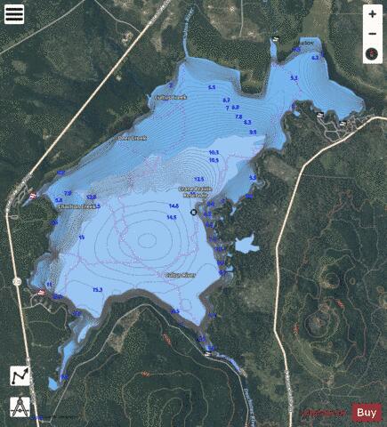
With our Lake Maps App, you get all the great marine chart app features like fishing spots, along with Crane Prairie Reservoir depth map. The fishing maps app include HD lake depth contours, along with advanced features found in Fish Finder / Gps Chart Plotter systems, turning your device into a Depth Finder. The Crane Prairie Reservoir Navigation App provides advanced features of a Marine Chartplotter including adjusting water level offset and custom depth shading. Fishing spots and depth contours layers are available in most Lake maps. Lake navigation features include advanced instrumentation to gather wind speed direction, water temperature, water depth, and accurate GPS with AIS receivers(using NMEA over TCP/UDP). Autopilot support can be enabled during ‘Goto WayPoint’ and ‘Route Assistance’.
Now i-Boating supports Fishing Points in Crane Prairie Reservoir.
Have more questions about the Nautical Chart App? Ask us.
Fishing Info for Crane Prairie Reservoir
Crane Prairie Reservoir is a man-made lake located about 42 miles (68 km) southwest of Bend in Deschutes County, Oregon, United States. The reservoir is named for the cranes that thrive in its habitat and for the upper Deschutes River prairie that once covered the area before the dam on the Deschutes was constructed in 1922. Eighteen years later, in 1940, the dam was rebuilt by the Bureau of Reclamation. The reservoir now serves as one of Oregon's largest rainbow trout fisheries. The heaviest fish ever caught in the lake was a 19-pound (8.6 kg) trout. The Deschutes River, which originates at Little Lava Lake, flows south for 8.4 miles (13.5 km) to Crane Prairie Reservoir. The river leaves the reservoir via the dam and continues south to Wickiup Reservoir.
More on Wikipedia...Popular fish species in this lake include Rainbow trout.
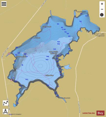

Crane Prairie Reservoir Fishing Map Stats | |
| Title | Crane Prairie Reservoir |
| Scale | 1:12000 |
| Counties | Deschutes |
| Nearby Cities | Crescent Lake, La Pine, Gilchrist, Crescent, McCredie Springs, Bend, McKenzie Bridge, Sisters, Chemult, Tumalo |
| Area * | 4170.44 acres |
| Shoreline * | 23.99 miles |
| Min Longitude | -121.84 |
| Min Latitude | 43.75 |
| Max Longitude | -121.76 |
| Max Latitude | 43.81 |
| Edition Label 1 | |
| Edition Label 2 | |
| Edition Label 3 | |
| Id | US_OR_ordfw_crane_prairie_reservoir |
| Country | US |
| Projection | Mercator |
| * some Stats may include nearby/connecting waterbodies | |
|