Cross Lake fishing map is available as part of iBoating : USA Marine & Fishing App(now supported on multiple platforms including Android, iPhone/iPad, MacBook, and Windows(tablet and phone)/PC based chartplotter.).
With our Lake Maps App, you get all the great marine chart app features like fishing spots, along with Cross Lake depth map. The fishing maps app include HD lake depth contours, along with advanced features found in Fish Finder / Gps Chart Plotter systems, turning your device into a Depth Finder. The Cross Lake Navigation App provides advanced features of a Marine Chartplotter including adjusting water level offset and custom depth shading. Fishing spots and depth contours layers are available in most Lake maps. Lake navigation features include advanced instrumentation to gather wind speed direction, water temperature, water depth, and accurate GPS with AIS receivers(using NMEA over TCP/UDP). Autopilot support can be enabled during ‘Goto WayPoint’ and ‘Route Assistance’.
Now i-Boating supports Fishing Points in Cross Lake.
Have more questions about the Nautical Chart App? Ask us.
Fishing Info for Cross Lake
Cross Lake (French: Lac de la Croix) is a man-made 8,575-acre (35 km2) lake located near Shreveport, Louisiana. The reservoir provides the water supply for the City of Shreveport. Moss covered cypress trees line the banks of this open lake popular for fishing and recreational boating. It supports waterfowl, alligators and an abundance of other wildlife. There are many access sites, several commercial facilities, and two public parks. The Cross Lake land was acquired by the City of Shreveport during the administration of Mayor , 1910-1914. The reservoir was constructed thereafter under the administration of Mayor , 1922-1930. Under Mayor Sam Caldwell, Cross Lake was stocked with fish. Ford Park, a recreational facility on the lake, is named for the former mayor and finance commissioner (1880–1965).
More on Wikipedia...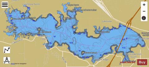
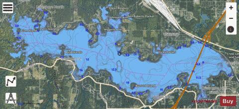
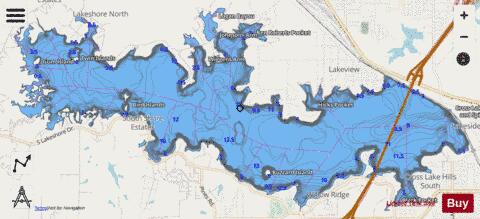
Cross Lake Fishing Map Stats | |
| Title | Cross Lake |
| Scale | 1:6000 |
| Counties | Caddo |
| Nearby Cities | Lakeview, Shreveport, Blanchard, Flournoy, North Highlands, Bossier City, Greenwood, Brownlee, Forbing, Waskom |
| Area * | 7043.26 acres |
| Shoreline * | 68.43 miles |
| Min Longitude | -93.93 |
| Min Latitude | 32.49 |
| Max Longitude | -93.79 |
| Max Latitude | 32.54 |
| Edition Label 1 | |
| Edition Label 2 | |
| Edition Label 3 | |
| Id | US_UB_LA_cross_lake |
| Country | US |
| Projection | Mercator |
| * some Stats may include nearby/connecting waterbodies | |
|