Desire Lake, King County fishing map is available as part of iBoating : USA Marine & Fishing App(now supported on multiple platforms including Android, iPhone/iPad, MacBook, and Windows(tablet and phone)/PC based chartplotter.).
With our Lake Maps App, you get all the great marine chart app features like fishing spots, along with Desire Lake, King County depth map. The fishing maps app include HD lake depth contours, along with advanced features found in Fish Finder / Gps Chart Plotter systems, turning your device into a Depth Finder. The Desire Lake, King County Navigation App provides advanced features of a Marine Chartplotter including adjusting water level offset and custom depth shading. Fishing spots and depth contours layers are available in most Lake maps. Lake navigation features include advanced instrumentation to gather wind speed direction, water temperature, water depth, and accurate GPS with AIS receivers(using NMEA over TCP/UDP). Autopilot support can be enabled during ‘Goto WayPoint’ and ‘Route Assistance’.
Now i-Boating supports Fishing Points in Desire Lake, King County.
Have more questions about the Nautical Chart App? Ask us.
Fishing Info for Desire Lake, King County
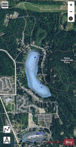
Lake Desire, also called Echo Lake, is an unimproved watershed 5 miles (8.0 km) southeast of Renton, Washington in the United States. It is a small part of the Maple Heights-Lake Desire, Washington area, 45 minutes east of downtown Seattle. According to King County, it has productive water quality, a maximum depth of 21 feet (6.4 m) and a surface area of approximately 80 acres. A public boat launch and fishing dock is located to the north of the lake but does require a vehicle use permit from the Washington Department of Fish and Wildlife. On the southeast border of the lake, a 382-acre (1.55 km2) forested park and wetland area has been allocated by the Washington Wildlife and Recreation Program (WWRP).
More on Wikipedia...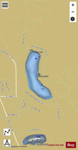
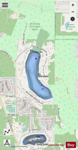
Desire Lake, King County Fishing Map Stats | |
| Title | Desire Lake, King County |
| Scale | 1:6000 |
| Counties | King |
| Nearby Cities | Cedar Mountain, Cedar Grove, Coalfield, Maplewood, Maple Valley, Covington, Berrydale, Newcastle, Issaquah, Renton |
| Area * | 68.89 acres |
| Shoreline * | 1.66 miles |
| Min Longitude | -122.11 |
| Min Latitude | 47.44 |
| Max Longitude | -122.10 |
| Max Latitude | 47.45 |
| Edition Label 1 | |
| Edition Label 2 | |
| Edition Label 3 | |
| Id | US_AA_WA_desire_lake_king |
| Country | US |
| Projection | Mercator |
| * some Stats may include nearby/connecting waterbodies | |
|