Kaw Lake fishing map is available as part of iBoating : USA Marine & Fishing App(now supported on multiple platforms including Android, iPhone/iPad, MacBook, and Windows(tablet and phone)/PC based chartplotter.).
With our Lake Maps App, you get all the great marine chart app features like fishing spots, along with Kaw Lake depth map. The fishing maps app include HD lake depth contours, along with advanced features found in Fish Finder / Gps Chart Plotter systems, turning your device into a Depth Finder. The Kaw Lake Navigation App provides advanced features of a Marine Chartplotter including adjusting water level offset and custom depth shading. Fishing spots and depth contours layers are available in most Lake maps. Lake navigation features include advanced instrumentation to gather wind speed direction, water temperature, water depth, and accurate GPS with AIS receivers(using NMEA over TCP/UDP). Autopilot support can be enabled during ‘Goto WayPoint’ and ‘Route Assistance’.
Now i-Boating supports Fishing Points in Kaw Lake.
Have more questions about the Nautical Chart App? Ask us.
Fishing Info for Kaw Lake
Kaw Lake is a reservoir completed in 1976 in the northern reaches of the U.S. state of Oklahoma, near Kaw City which is located on a hill overlooking the lake. The lake is approximately 8 miles (13 km) east of Ponca City. Newkirk is 6 miles (9.7 km) west of the upper end of the lake. Kaw Dam is 9,466 feet (2,885 m) long and 121 feet (37 m) above the stream bed. The dam lies 654 miles (1,053 km) above the mouth of the Arkansas River. The top of the flood control pool is 1,044.5 feet (318.4 m), while the normal operating level is 1,010 feet. The Reservoir covers approximately 17,040 acres (69 km²). It is the seventh largest lake in Oklahoma by surface area. At normal levels, the lake holds 428,600 acre-feet (528,700,000 m3) of water, the ninth largest lake in capacity in Oklahoma. (See List of lakes in Oklahoma) It lies mostly in Kay County and partially in Osage County. Kaw Dam was authorized by Congress in the Flood Control Act of 1962. Ground was broken for the dam on May 21, 1966. The original town of Kaw City was covered by the waters of Kaw Lake in 1975. The city was rebuilt about two miles west of the old site during the late 1960s. The dam was completed by the Corps of Engineers in May 1976. The cost of the dam and the lake was $111 million. The Oklahoma Municipal Power Authority (OMPA), a state governmental agency created in 1981 to provide wholesale electricity to cities and towns in Oklahoma, purchased the substructure of the dam in July 1987 at a cost of $3.8 million and constructed a hydroelectric plant that was completed in September 1989 at a cost of $25 million. Kaw Hydroelectric generates approximately 104 gigawatt hours of energy annually. The generator is nominally rated at 25.6 megawatts at 76 feet (23 m) of gross head with a maximum rating of 36.7 MVA. The plant at Kaw Dam provides power for over 35 municipal electrical systems in Oklahoma and southern Kansas. The project engineer for the Kaw Lake dam was Everette W. Woodham, Jr. The Corps of Engineers and Camp McFadden offers camping on the west shore of Kaw Lake at Ponca Cove. The City of Enid began a project in 2020 to lay a 70-mile pipeline to tap Kaw Lake as a municipal water source. The project will transport 10 million gallons of water per day.
More on Wikipedia...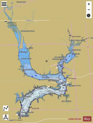


Kaw Lake Fishing Map Stats | |
| Title | Kaw Lake |
| Scale | 1:24000 |
| Counties | Kay, Osage |
| Nearby Cities | Kaw City, Uncas, Webb City, Burbank, Shidler, Hardy, Newkirk, Grainola, Kildare, Silverdale |
| Area * | 16218.14 acres |
| Shoreline * | 149.09 miles |
| Min Longitude | -96.96 |
| Min Latitude | 36.70 |
| Max Longitude | -96.76 |
| Max Latitude | 36.91 |
| Edition Label 1 | |
| Edition Label 2 | |
| Edition Label 3 | |
| Id | US_UB_OK_01754455 |
| Country | US |
| Projection | Mercator |
| * some Stats may include nearby/connecting waterbodies | |
|