Table Rock Lake fishing map is available as part of iBoating : USA Marine & Fishing App(now supported on multiple platforms including Android, iPhone/iPad, MacBook, and Windows(tablet and phone)/PC based chartplotter.).
With our Lake Maps App, you get all the great marine chart app features like fishing spots, along with Table Rock Lake depth map. The fishing maps app include HD lake depth contours, along with advanced features found in Fish Finder / Gps Chart Plotter systems, turning your device into a Depth Finder. The Table Rock Lake Navigation App provides advanced features of a Marine Chartplotter including adjusting water level offset and custom depth shading. Fishing spots and depth contours layers are available in most Lake maps. Lake navigation features include advanced instrumentation to gather wind speed direction, water temperature, water depth, and accurate GPS with AIS receivers(using NMEA over TCP/UDP). Autopilot support can be enabled during ‘Goto WayPoint’ and ‘Route Assistance’.
Now i-Boating supports Fishing Points in Table Rock Lake.
Have more questions about the Nautical Chart App? Ask us.
Fishing Info for Table Rock Lake
Table Rock Lake is an artificial lake or reservoir in the Ozarks of southwestern Missouri and northwestern Arkansas in the United States. Designed, built and operated by the U.S. Army Corps of Engineers, the lake is impounded by Table Rock Dam (located 36°35′43″N 93°18′40″W / 36.595374°N 93.311137°W), which was constructed from 1954 to 1958 on the White River. The lake is a popular attraction for the city of Branson, Missouri, and the nearby town of Shell Knob, Missouri. There are several commercial marinas along the lake, and Table Rock State Park is located on the east side, both north and south of Table Rock Dam. Downstream from the dam, the Missouri Department of Conservation operates a fish hatchery, which is used to stock trout in Lake Taneycomo, which begins immediately downstream from the Table Rock Dam. The cold water discharged from the dam creates a trout fishing environment in the lake. The lake derives its name from a rock formation resembling a table at the small community of Table Rock, Missouri, on Highway 165 about a mile and a half downstream from where the dam was built.
More on Wikipedia...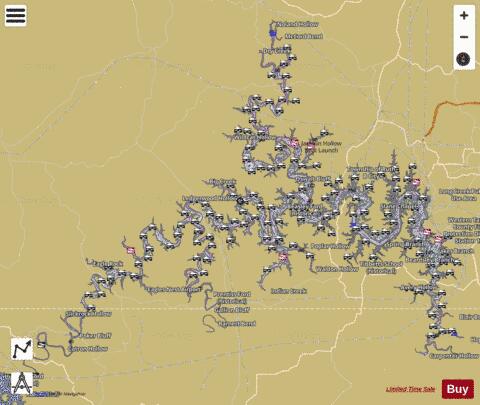
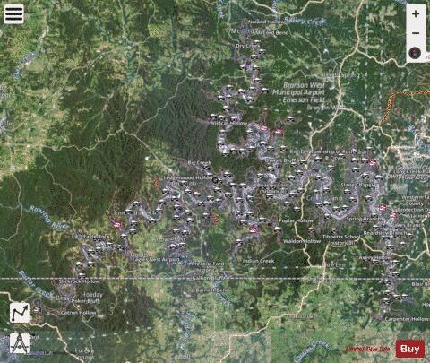
Table Rock Lake Fishing Map Stats | |
| Title | Table Rock Lake |
| Scale | 1:24000 |
| Counties | Boone, Carroll, Barry, Stone, Taney |
| Nearby Cities | Eagle Rock, Beaver, Coney Island, Indian Point, Kimberling City, Arrow Point, Chain-O-Lakes, McCord Bend, Emerald Beach, Cape Fair |
| Area * | 41777.82 acres |
| Shoreline * | 758.35 miles |
| Min Longitude | -93.85 |
| Min Latitude | 36.42 |
| Max Longitude | -93.26 |
| Max Latitude | 36.80 |
| Edition Label 1 | |
| Edition Label 2 | |
| Edition Label 3 | |
| Id | US_MO_00752479 |
| Country | US |
| Projection | Mercator |
| * some Stats may include nearby/connecting waterbodies | |
|