LAKE OTIS fishing map is available as part of iBoating : USA Marine & Fishing App(now supported on multiple platforms including Android, iPhone/iPad, MacBook, and Windows(tablet and phone)/PC based chartplotter.).
With our Lake Maps App, you get all the great marine chart app features like fishing spots, along with LAKE OTIS depth map. The fishing maps app include HD lake depth contours, along with advanced features found in Fish Finder / Gps Chart Plotter systems, turning your device into a Depth Finder. The LAKE OTIS Navigation App provides advanced features of a Marine Chartplotter including adjusting water level offset and custom depth shading. Fishing spots and depth contours layers are available in most Lake maps. Lake navigation features include advanced instrumentation to gather wind speed direction, water temperature, water depth, and accurate GPS with AIS receivers(using NMEA over TCP/UDP). Autopilot support can be enabled during ‘Goto WayPoint’ and ‘Route Assistance’.
Now i-Boating supports Fishing Points in LAKE OTIS.
Have more questions about the Nautical Chart App? Ask us.
Fishing Info for LAKE OTIS
Lake Otis is a natural freshwater lake located on the east side of Winter Haven, Florida. The Polk County Water Atlas says the lake sometimes is known as Little Otis, but this is confirmed nowhere else. The main part of the lake is somewhat rectangular in shape and on the south side of the main section of the lake is a long tail-shaped cove. Lake Otis has a 144 acres (58 ha) surface. It is connected on its northeast side to nearby Lake Link by a 50 feet (15 m) canal. This is the closest point between the two lakes. Other than where the shore where the two lakes are very close, Lake Otis is completely surrounded by residences. Lakewood Causeway runs between the two lakes. To the south of this area is a gated community that can be accessed by the public during the daytime. Most of the south cove is surrounded by another gated community and the public is prevented from entering it by gates that are closed all the time. Lake Otis has no public boat ramps or swimming areas. In fact, there are no areas of the shore accessible to the public. The entire shore of the lake, other than the area near Lake Link, has steep banks. The Hook and Bullet website, however, says Lake Otis contains largemouth bass, bluegill and crappie.
More on Wikipedia...Popular fish species in this lake include Crappie and Largemouth bass.
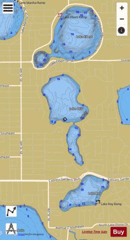
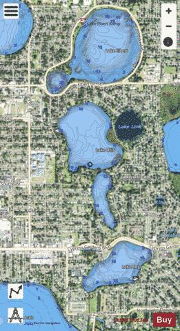
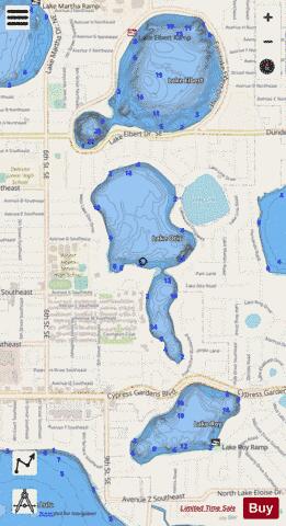
LAKE OTIS Fishing Map Stats | |
| Title | LAKE OTIS |
| Scale | 1:6000 |
| 1 ft Depth Contours for Anglers | Yes |
| Counties | Polk |
| Nearby Cities | Winter Haven, Inwood, Eagle Lake, Wahneta, Lake Alfred, Lake Hamilton, Auburndale, Dundee, Waverly, West Lake Wales |
| Area * | 139.26 acres |
| Shoreline * | 2.85 miles |
| Min Longitude | -81.72 |
| Min Latitude | 28.01 |
| Max Longitude | -81.71 |
| Max Latitude | 28.02 |
| Edition Label 1 | |
| Edition Label 2 | |
| Edition Label 3 | |
| Id | US_FL_00288273 |
| Country | US |
| Projection | Mercator |
| * some Stats may include nearby/connecting waterbodies | |
|