LAKE MAUDE fishing map is available as part of iBoating : USA Marine & Fishing App(now supported on multiple platforms including Android, iPhone/iPad, MacBook, and Windows(tablet and phone)/PC based chartplotter.).
With our Lake Maps App, you get all the great marine chart app features like fishing spots, along with LAKE MAUDE depth map. The fishing maps app include HD lake depth contours, along with advanced features found in Fish Finder / Gps Chart Plotter systems, turning your device into a Depth Finder. The LAKE MAUDE Navigation App provides advanced features of a Marine Chartplotter including adjusting water level offset and custom depth shading. Fishing spots and depth contours layers are available in most Lake maps. Lake navigation features include advanced instrumentation to gather wind speed direction, water temperature, water depth, and accurate GPS with AIS receivers(using NMEA over TCP/UDP). Autopilot support can be enabled during ‘Goto WayPoint’ and ‘Route Assistance’.
Now i-Boating supports Fishing Points in LAKE MAUDE.
Have more questions about the Nautical Chart App? Ask us.
Fishing Info for LAKE MAUDE
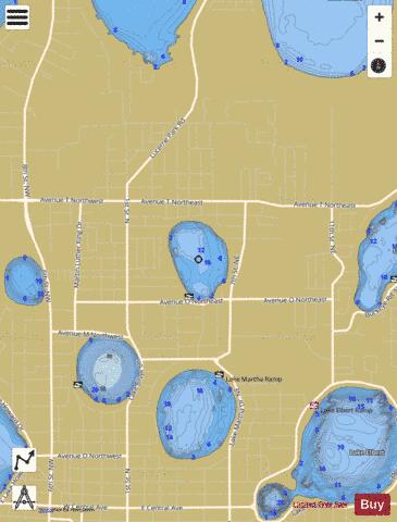
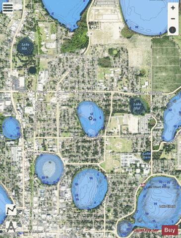
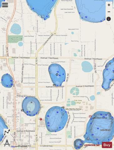
Lake Maude is an oval-shaped lake on the north side of Winter Haven, Florida. It has a surface area of 54.83-acre (221,900 m2). On its north and west sides, Lake Maude is bordered by residential areas. On its entire east side is Lake Maude Nature Park and on the south Lake Maude is bordered by Avenue O Northeast. Lake Maude allows for much public access. A public boat ramp is on the south shore, just off Avenue O Northeast. The Lake Maude Nature Park is located along the entire east shore of the lake. The nature park has a paved walking trail, 0.9 miles (1.4 km) long, picnic facilities, a playground, two public fishing piers and a nature observation deck. This lake does not have a public swimming area, however. The Hook and Bullet website says Lake Maude contains largemouth bass, bluegill and crappie.
More on Wikipedia...Popular fish species in this lake include Crappie and Largemouth bass.
LAKE MAUDE Fishing Map Stats | |
| Title | LAKE MAUDE |
| Scale | 1:3000 |
| 1 ft Depth Contours for Anglers | Yes |
| Counties | Polk |
| Nearby Cities | Winter Haven, Inwood, Lake Alfred, Eagle Lake, Auburndale, Wahneta, Lake Hamilton, Dundee, Waverly, Haines City |
| Area * | 53.54 acres |
| Shoreline * | 1.08 miles |
| Min Longitude | -81.72 |
| Min Latitude | 28.04 |
| Max Longitude | -81.72 |
| Max Latitude | 28.04 |
| Edition Label 1 | |
| Edition Label 2 | |
| Edition Label 3 | |
| Id | US_FL_00286529 |
| Country | US |
| Projection | Mercator |
| * some Stats may include nearby/connecting waterbodies | |
|