CLEAR LAKE fishing map is available as part of iBoating : USA Marine & Fishing App(now supported on multiple platforms including Android, iPhone/iPad, MacBook, and Windows(tablet and phone)/PC based chartplotter.).
With our Lake Maps App, you get all the great marine chart app features like fishing spots, along with CLEAR LAKE depth map. The fishing maps app include HD lake depth contours, along with advanced features found in Fish Finder / Gps Chart Plotter systems, turning your device into a Depth Finder. The CLEAR LAKE Navigation App provides advanced features of a Marine Chartplotter including adjusting water level offset and custom depth shading. Fishing spots and depth contours layers are available in most Lake maps. Lake navigation features include advanced instrumentation to gather wind speed direction, water temperature, water depth, and accurate GPS with AIS receivers(using NMEA over TCP/UDP). Autopilot support can be enabled during ‘Goto WayPoint’ and ‘Route Assistance’.
Now i-Boating supports Fishing Points in CLEAR LAKE.
Have more questions about the Nautical Chart App? Ask us.
Fishing Info for CLEAR LAKE
Clear Lake is a 357-acre (1,440,000 m2) freshwater lake located in central Orlando, Florida. This lake, somewhat lemon shaped, is surrounded by a residential area. A series of canals on the lake's southwest provide boat access for the houses there. John Young Parkway borders the lake on part of its west side. A very small portion of John Young Parkway crosses the extreme western part of Clear Lake. Fishing, walking and boating are popular activities. There are no public swimming areas on the shore of this lake. Three public parks border Clear Lake. On the extreme western edge is Washington Shore Park, which is mainly a park with a track, football field and four softball fields. Another park, Clear Lake Park, is on the southeast edge of the lake. This park has walking trails, a fishing dock and a boardwalk. A third park, George Barker Memorial Park, is on the northeast corner of the lake. A public boat ramp in this park is on a canal leading to Clear Lake. This park also has two fishing piers, playgrounds, a volleyball court and a basketball court. The Take Me Fishing website says this lake contains largemouth bass, wiper (hybrid striped bass) and bluegill.
More on Wikipedia...Popular fish species in this lake include Largemouth bass.
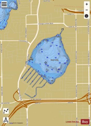
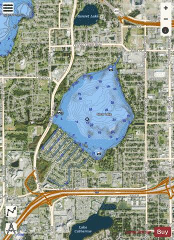
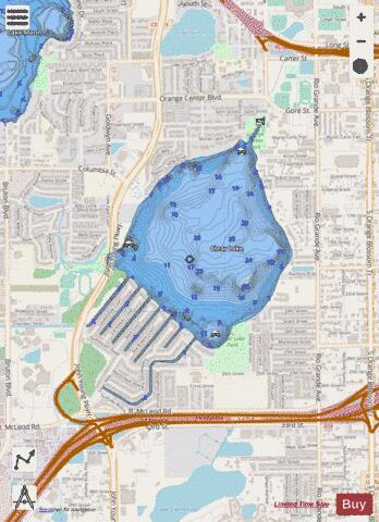
CLEAR LAKE Fishing Map Stats | |
| Title | CLEAR LAKE |
| Scale | 1:6000 |
| 1 ft Depth Contours for Anglers | Yes |
| Counties | Orange |
| Nearby Cities | Orlando, Edgewood, Orlovista, Pine Hills, Sky Lake, Pine Castle, Fairview Shores, Tangelo Park, Belle Isle, Conway |
| Area * | 357.53 acres |
| Shoreline * | 7.74 miles |
| Min Longitude | -81.42 |
| Min Latitude | 28.51 |
| Max Longitude | -81.40 |
| Max Latitude | 28.53 |
| Edition Label 1 | |
| Edition Label 2 | |
| Edition Label 3 | |
| Id | US_FL_00280529 |
| Country | US |
| Projection | Mercator |
| * some Stats may include nearby/connecting waterbodies | |
|