Saugatuck Reservoir fishing map is available as part of iBoating : USA Marine & Fishing App(now supported on multiple platforms including Android, iPhone/iPad, MacBook, and Windows(tablet and phone)/PC based chartplotter.).
With our Lake Maps App, you get all the great marine chart app features like fishing spots, along with Saugatuck Reservoir depth map. The fishing maps app include HD lake depth contours, along with advanced features found in Fish Finder / Gps Chart Plotter systems, turning your device into a Depth Finder. The Saugatuck Reservoir Navigation App provides advanced features of a Marine Chartplotter including adjusting water level offset and custom depth shading. Fishing spots and depth contours layers are available in most Lake maps. Lake navigation features include advanced instrumentation to gather wind speed direction, water temperature, water depth, and accurate GPS with AIS receivers(using NMEA over TCP/UDP). Autopilot support can be enabled during ‘Goto WayPoint’ and ‘Route Assistance’.
Now i-Boating supports Fishing Points in Saugatuck Reservoir.
Have more questions about the Nautical Chart App? Ask us.
Fishing Info for Saugatuck Reservoir
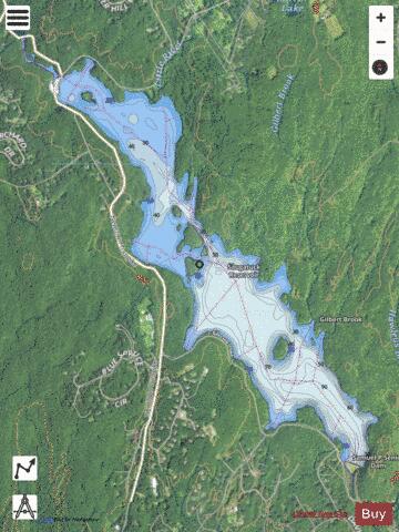
The Saugatuck Reservoir is a reservoir in Fairfield County, Connecticut, United States, that straddles the border between the towns of Redding, Weston, and Easton. Its completion is marked by the creation of the Samuel P. Senior dam of the Saugatuck River in January 1942, and provides water to several of the nearby towns. The reservoir is surrounded by the Centennial Watershed State Forest and a small section of the Trout Brook Valley State Park Reserve on the southeast end of the reservoir. The Saugatuck Reservoir utilizes an uncontrolled spillway adjacent to the Samuel P. Senior dam that effectively limits the maximum water level. There is also a concrete levee positioned on the southeastern side of the reservoir that prevents water from flooding Trout Brook Valley. Bridgeport Hydraulic Company Holdings (now owned by Aquarion) flooded the Saugatuck River Valley after 1938, removing the villages of Hull and Valley Forge to create the Saugatuck Reservoir. , owner of the reservoir and dam, allows tailrace fishing in one area at the Weston end of the reservoir, where it has constructed a handicapped-access area. However, anglers must obtain a permit from Aquarion before fishing in the Saugatuck. The Saugatuck is the largest of the eight reservoirs that make up Aquarion’s greater Bridgeport water system. It holds about 12 billion US gallons (45,000,000 m3) of water. The following fish species may be found within the Saugatuck Reservoir: American eelBluegill (Sunfish)Brook troutBrown troutBullhead catfishChain pickerelCrappieLargemouth bassPumpkinseed (Sunfish)Rainbow troutRock bassSmallmouth bassWalleyeWhite perchYellow perch
More on Wikipedia...Popular fish species in this lake include American eel, Brook trout, Chain pickerel, Crappie, Largemouth bass, Pumpkinseed, Rainbow trout, Rock bass, Smallmouth bass, Walleye and Yellow perch.
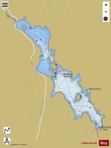
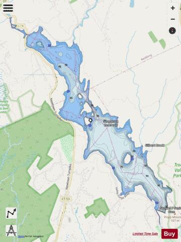
Saugatuck Reservoir Fishing Map Stats | |
| Title | Saugatuck Reservoir |
| Scale | 1:12000 |
| Counties | Fairfield |
| Nearby Cities | Redding, Lyons Plain, Aspetuck, Easton, Georgetown, Branchville, Weston, Topstone, Cannondale, Bethel |
| Area * | 824.09 acres |
| Shoreline * | 15.47 miles |
| Min Longitude | -73.39 |
| Min Latitude | 41.25 |
| Max Longitude | -73.35 |
| Max Latitude | 41.29 |
| Edition Label 1 | |
| Edition Label 2 | |
| Edition Label 3 | |
| Id | US_CT_ctserv_saugatuck_reservoir |
| Country | US |
| Projection | Mercator |
| * some Stats may include nearby/connecting waterbodies | |
|