Harry L. Englebright Lake fishing map is available as part of iBoating : USA Marine & Fishing App(now supported on multiple platforms including Android, iPhone/iPad, MacBook, and Windows(tablet and phone)/PC based chartplotter.).
With our Lake Maps App, you get all the great marine chart app features like fishing spots, along with Harry L. Englebright Lake depth map. The fishing maps app include HD lake depth contours, along with advanced features found in Fish Finder / Gps Chart Plotter systems, turning your device into a Depth Finder. The Harry L. Englebright Lake Navigation App provides advanced features of a Marine Chartplotter including adjusting water level offset and custom depth shading. Fishing spots and depth contours layers are available in most Lake maps. Lake navigation features include advanced instrumentation to gather wind speed direction, water temperature, water depth, and accurate GPS with AIS receivers(using NMEA over TCP/UDP). Autopilot support can be enabled during ‘Goto WayPoint’ and ‘Route Assistance’.
Now i-Boating supports Fishing Points in Harry L. Englebright Lake.
Have more questions about the Nautical Chart App? Ask us.
Fishing Info for Harry L. Englebright Lake
Englebright Lake is an 815 acre reservoir on the Yuba River, impounded by Englebright Dam, in the Sierra Nevada, Northern California, United States. The reservoir stores 45,000 acre feet of water with nearly 24 miles of shoreline. It is located in Yuba County and Nevada County. The boat launch and marina, named Skippers Cove, are located in Smartsville. It is located in between Grass Valley and Marysville. The reservoir, as well as the dam, were named for former U.S. Representative Harry L. Englebright, who represented the district in which Englebright is located. The California Office of Environmental Health Hazard Assessment (OEHHA) has developed a safe eating advisory for the Englebright Lake based on levels of mercury found in fish caught here.
More on Wikipedia...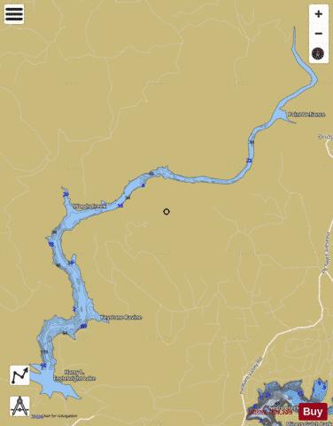
Harry L. Englebright Lake Fishing Map Stats | |
| Title | Harry L. Englebright Lake |
| Scale | 1:3000 |
| Counties | Nevada, Yuba |
| Nearby Cities | Smartsville, Dobbins, Rough and Ready, North San Juan, Loma Rica, Grass Valley, Brownsville, Challenge, Bangor, Rackerby |
| Area * | 707.49 acres |
| Shoreline * | 22.12 miles |
| Min Longitude | -121.28 |
| Min Latitude | 39.24 |
| Max Longitude | -121.20 |
| Max Latitude | 39.31 |
| Edition Label 1 | |
| Edition Label 2 | |
| Edition Label 3 | |
| Id | US_CA_00233986 |
| Country | US |
| Projection | Mercator |
| * some Stats may include nearby/connecting waterbodies | |
|