Kashagawigamog Lake fishing map is included in Ontario Lakes nautical charts folio. It is available as part of iBoating : Canada Marine & Fishing App (now supported on multiple platforms including Android, iPhone/iPad, MacBook, and Windows(tablet and phone)/PC based chartplotter. ).
With our Lake Maps App, you get all the great marine chart app features like fishing spots, along with Kashagawigamog Lake depth map. The fishing maps app include HD lake depth contours, along with advanced features found in Fish Finder / Gps Chart Plotter systems, turning your device into a Depth Finder. The Kashagawigamog Lake Navigation App provides advanced features of a Marine Chartplotter including adjusting water level offset and custom depth shading. Fishing spots and depth contours layers are available in most Lake maps. Lake navigation features include advanced instrumentation to gather wind speed direction, water temperature, water depth, and accurate GPS with AIS receivers(using NMEA over TCP/UDP). Autopilot support can be enabled during ‘Goto WayPoint’ and ‘Route Assistance’.
Now i-Boating supports Fishing Points in Kashagawigamog Lake.
Have more questions about the Nautical Chart App? Ask us.
Fishing Info for Kashagawigamog Lake
Kashagawigamog Lake is a lake in Haliburton County, Ontario, Canada. It is in the "cottage country" area of central Ontario and has many cottages along its shores. It is the central lake in a five-lake chain running southwest from the town of Haliburton to as far as Minden. Connected to Grass Lake and Head Lake to the east, to the north, and to the west, the lake is long and narrow. The lake is essentially a widening of the Drag River, which flows from Drag Lake into the chain of lakes at Head Lake and out again at Canning Lake where a dam is controlled by the Trent-Severn Waterway. Residents of Kashawigamog Lake are represented by the Lake Kashagawigamog Organization.
More on Wikipedia...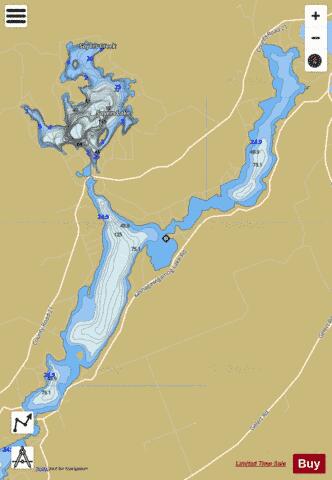
Kashagawigamog Lake Fishing Map Stats | |
| Title | Kashagawigamog Lake |
| Scale | 1:12000 |
| Districts | Haliburton |
| Nearby Cities | Haliburton Village, Bobcaygeon, Fenelon Falls, Lindsay, Bridgenorth - Chemong Park Area, Lakefield, Omemee, Bracebridge, Huntsville, Peterborough |
| Area * | 2082.80 acres |
| Shoreline * | 23.55 miles |
| Min Longitude | -78.63 |
| Min Latitude | 44.95 |
| Max Longitude | -78.54 |
| Max Latitude | 45.04 |
| Edition Label 1 | |
| Edition Label 2 | |
| Edition Label 3 | |
| Id | CA_ON_V_103380794 |
| Country | CA |
| Projection | Mercator |
| * some Stats may include nearby/connecting waterbodies | |
|