Charleston Lake fishing map is included in Ontario Lakes nautical charts folio. It is available as part of iBoating : Canada Marine & Fishing App (now supported on multiple platforms including Android, iPhone/iPad, MacBook, and Windows(tablet and phone)/PC based chartplotter. ).
With our Lake Maps App, you get all the great marine chart app features like fishing spots, along with Charleston Lake depth map. The fishing maps app include HD lake depth contours, along with advanced features found in Fish Finder / Gps Chart Plotter systems, turning your device into a Depth Finder. The Charleston Lake Navigation App provides advanced features of a Marine Chartplotter including adjusting water level offset and custom depth shading. Fishing spots and depth contours layers are available in most Lake maps. Lake navigation features include advanced instrumentation to gather wind speed direction, water temperature, water depth, and accurate GPS with AIS receivers(using NMEA over TCP/UDP). Autopilot support can be enabled during ‘Goto WayPoint’ and ‘Route Assistance’.
Now i-Boating supports Fishing Points in Charleston Lake.
Have more questions about the Nautical Chart App? Ask us.
Fishing Info for Charleston Lake
Charleston Lake is located in South Eastern Ontario, just north east of Gananoque. The lake is carved out of the Frontenac Axis, a relatively narrow extension of the Canadian Shield bedrock which dominates the landscape of Northern Ontario. The lake is the principal watershed for the Gananoque River, and boasts prime fishing locations. Charleston Lake Provincial Park is located on the shores of the lake, and offers camping, hiking, boating, fishing and interpretive sessions. Charleston Lake has over 100 miles of shoreline and over 100 islands with over 800 summer and permanent residences on the lake. The water surface is 26.2 km2, and the maximum depth is 91.1 m. A naturally occurring rock and tree formation shows a profile of the guardian of Charleston Lake known as Indian Head. Other than Charleston Lake Provincial Park, the County Park and Sand Bay are excellent destinations for day trips. For five years culminating in 2005, Charleston Lake was the site for re-introduction of the peregrine falcon with the Canadian Peregrine Foundation, Ontario Power Generation and Leeds County Stewardship Council.
More on Wikipedia...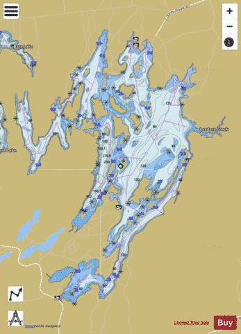
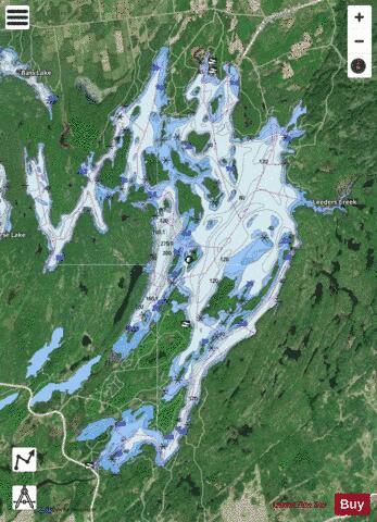
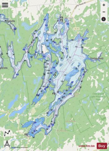
Charleston Lake Fishing Map Stats | |
| Title | Charleston Lake |
| Scale | 1:24000 |
| Districts | Leeds and Grenville |
| Nearby Cities | Gananoque, Brockville, Smiths Falls, Perth, Prescott, Kingston, Kemptville, Carleton Place, Cardinal, Richmond |
| Area * | 6477.92 acres |
| Shoreline * | 109.62 miles |
| Min Longitude | -76.07 |
| Min Latitude | 44.48 |
| Max Longitude | -75.96 |
| Max Latitude | 44.58 |
| Edition Label 1 | |
| Edition Label 2 | |
| Edition Label 3 | |
| Id | CA_ON_V_103380211 |
| Country | CA |
| Projection | Mercator |
| * some Stats may include nearby/connecting waterbodies | |
|