Lene fishing map is included in Ireland - Loughs in Westmeath nautical charts folio. It is available as part of iBoating : Inland Europe Marine & Fishing App (now supported on multiple platforms including Android, iPhone/iPad, MacBook, and Windows(tablet and phone)/PC based chartplotter. ).
With our Lake Maps App, you get all the great marine chart app features like fishing spots, along with Lene lake depth map. The fishing maps app include HD lake depth contours, along with advanced features found in Fish Finder / Gps Chart Plotter systems, turning your device into a Depth Finder. The Lene Navigation App provides advanced features of a Marine Chartplotter including adjusting water level offset and custom depth shading. Fishing spots and depth contours layers are available in most Lake maps. Lake navigation features include advanced instrumentation to gather wind speed direction, water temperature, water depth, and accurate GPS with AIS receivers(using NMEA over TCP/UDP). Autopilot support can be enabled during ‘Goto WayPoint’ and ‘Route Assistance’.
Have more questions about the Nautical Chart App? Ask us.
Fishing Info for Lene
Lough Lene (Irish: Loch Léinn) is a lake situated in north County Westmeath, Ireland, between the villages of Castlepollard, Collinstown and Fore. It possesses a rich and varied history. It also boasts the existence of prehistoric burial sites, old ruins, many ancient village-type communal circular dwellings locally called ringforts, stiles, and mass paths. Lough Lene also has claims to being the home to kings and Vikings, such as Turgesius who had one of his forts upon the hill on the southwest overlooking the lake from the Ranaghan side, before being killed by Máel Sechnaill mac Maíl Ruanaid.
More on Wikipedia...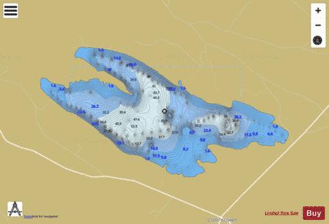
Lene Fishing Map Stats | |
| Title | Lene |
| Scale | 1:12000 |
| Area * | 1028.43 acres |
| Shoreline * | 8.97 miles |
| Min Longitude | -7.26 |
| Min Latitude | 53.65 |
| Max Longitude | -7.19 |
| Max Latitude | 53.67 |
| Edition Label 1 | |
| Edition Label 2 | |
| Edition Label 3 | |
| Id | II_IE_07_274_Lene |
| Country | Inland Europe |
| Projection | Mercator |
| * some Stats may include nearby/connecting waterbodies | |
|