Hastings Lake fishing map is included in Alberta Lakes nautical charts folio. It is available as part of iBoating : Canada Marine & Fishing App (now supported on multiple platforms including Android, iPhone/iPad, MacBook, and Windows(tablet and phone)/PC based chartplotter. ).
With our Lake Maps App, you get all the great marine chart app features like fishing spots, along with Hastings Lake depth map. The fishing maps app include HD lake depth contours, along with advanced features found in Fish Finder / Gps Chart Plotter systems, turning your device into a Depth Finder. The Hastings Lake Navigation App provides advanced features of a Marine Chartplotter including adjusting water level offset and custom depth shading. Fishing spots and depth contours layers are available in most Lake maps. Lake navigation features include advanced instrumentation to gather wind speed direction, water temperature, water depth, and accurate GPS with AIS receivers(using NMEA over TCP/UDP). Autopilot support can be enabled during ‘Goto WayPoint’ and ‘Route Assistance’.
Now i-Boating supports Fishing Points in Hastings Lake.
Have more questions about the Nautical Chart App? Ask us.
Fishing Info for Hastings Lake
Hastings Lake is a lake in Alberta. It is located in Strathcona County, east of Cooking Lake. The hamlet of Hastings Lake lies on the southern shore of the lake. The lake was renamed in 1884 for Tom Hastings, a member of Tyrell's geological survey party. The original name was Kawtikh, which in the Cree language means "the lake that does not freeze". The large forested area in the Hastings Lake Watershed is a key area for moose and white-tailed deer. With close proximity to the Cooking Lake-Blackfoot Wildlife, Grazing and Provincial Recreation Area and the Waskahegan Staging Area, many hiking and cross-country skiing possibilities exists. For many years Hastings Lake has been an attraction for bird enthusiasts as it is home to many species of water birds. The white pelican and the cormorant make it a bird-watching destination. The islands of Hastings Lake were named as one of the "Special Places 2000" by the Alberta Government. Activities include kayaking, canoeing, paddle boarding, or other water-based activities.
More on Wikipedia...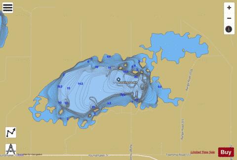
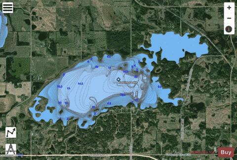
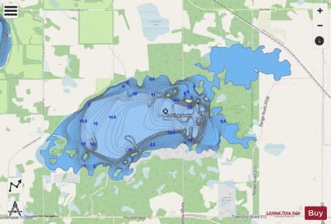
Hastings Lake Fishing Map Stats | |
| Title | Hastings Lake |
| Scale | 1:12000 |
| Districts | Division No. 11 |
| Nearby Cities | Tofield, Lamont, Fort Saskatchewan, Camrose, Beaumont, Edmonton, Gibbons, Redwater, Lancaster Park, Wetaskiwin |
| Area * | 1897.04 acres |
| Shoreline * | 21.40 miles |
| Min Longitude | -112.95 |
| Min Latitude | 53.40 |
| Max Longitude | -112.86 |
| Max Latitude | 53.43 |
| Edition Label 1 | |
| Edition Label 2 | |
| Edition Label 3 | |
| Id | CA_AB_hastings_lake |
| Country | CA |
| Projection | Mercator |
| * some Stats may include nearby/connecting waterbodies | |
|