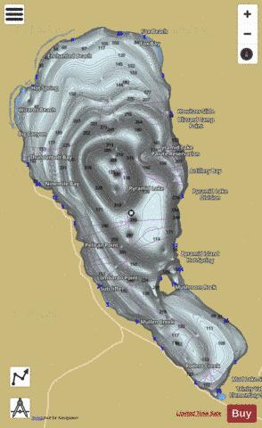
Pyramid Lake fishing map is available as part of iBoating : USA Marine & Fishing App(now supported on multiple platforms including Android, iPhone/iPad, MacBook, and Windows(tablet and phone)/PC based chartplotter.).
With our Lake Maps App, you get all the great marine chart app features like fishing spots, along with Pyramid Lake depth map. The fishing maps app include HD lake depth contours, along with advanced features found in Fish Finder / Gps Chart Plotter systems, turning your device into a Depth Finder. The Pyramid Lake Navigation App provides advanced features of a Marine Chartplotter including adjusting water level offset and custom depth shading. Fishing spots and depth contours layers are available in most Lake maps. Lake navigation features include advanced instrumentation to gather wind speed direction, water temperature, water depth, and accurate GPS with AIS receivers(using NMEA over TCP/UDP). Autopilot support can be enabled during ‘Goto WayPoint’ and ‘Route Assistance’.
Now i-Boating supports Fishing Points in Pyramid Lake.
Have more questions about the Nautical Chart App? Ask us.
Fishing Info for Pyramid Lake
Pyramid Lake is the geographic sink of the basin of the Truckee River, 40 mi (64 km) northeast of Reno, Nevada, United States. Pyramid Lake is the biggest remnant of ancient Lake Lahontan, the colossal inland sea that once covered most of Nevada. It is approximately 15 miles long and 11 miles wide, covering 112,000 acres entirely enclosed within the Pyramid Lake Paiute Tribe Reservation. Pyramid Lake is fed by the Truckee River, which is mostly the outflow from Lake Tahoe. The Truckee River enters Pyramid Lake at its southern end. Pyramid Lake is an endorheic lake. It has no outlet, with water left only by evaporation, or sub-surface seepage. The lake has about 10% of the area of the Great Salt Lake, but it has about 25% more volume. The salinity is approximately 1/6 that of sea water. Although clear Lake Tahoe forms the headwaters that drain to Pyramid Lake, the Truckee River delivers more turbid waters to Pyramid Lake after traversing the steep Sierra terrain and collecting moderately high silt-loaded surface runoff. The north and east sides of the lake have been restricted to the public and non-Tribal members for nearly a decade. In 2011, the Tribal Nation made the decision to close these areas due to the desecration of sacred sites. When visiting, it is recommended to take note of the Tribal protocols and restricted areas.
More on Wikipedia...Popular fish species in this lake include Cui-ui and Tui chub.
Pyramid Lake Fishing Map Stats | |
| Title | Pyramid Lake |
| Scale | 1:12000 |
| Counties | Washoe |
| Nearby Cities | Sutcliffe, Pyramid, Nixon, Sand Pass, Flanigan, Wadsworth, Fernley, Patrick, Sun Valley, Doyle |
| Area * | 108982.32 acres |
| Shoreline * | 74.91 miles |
| Min Longitude | -119.70 |
| Min Latitude | 39.84 |
| Max Longitude | -119.41 |
| Max Latitude | 40.20 |
| Edition Label 1 | |
| Edition Label 2 | |
| Edition Label 3 | |
| Id | US_UB_NV_00856349 |
| Country | US |
| Projection | Mercator |
| * some Stats may include nearby/connecting waterbodies | |
|


