Walker Lake fishing map is available as part of iBoating : USA Marine & Fishing App(now supported on multiple platforms including Android, iPhone/iPad, MacBook, and Windows(tablet and phone)/PC based chartplotter.).
With our Lake Maps App, you get all the great marine chart app features like fishing spots, along with Walker Lake depth map. The fishing maps app include HD lake depth contours, along with advanced features found in Fish Finder / Gps Chart Plotter systems, turning your device into a Depth Finder. The Walker Lake Navigation App provides advanced features of a Marine Chartplotter including adjusting water level offset and custom depth shading. Fishing spots and depth contours layers are available in most Lake maps. Lake navigation features include advanced instrumentation to gather wind speed direction, water temperature, water depth, and accurate GPS with AIS receivers(using NMEA over TCP/UDP). Autopilot support can be enabled during ‘Goto WayPoint’ and ‘Route Assistance’.
Now i-Boating supports Fishing Points in Walker Lake.
Have more questions about the Nautical Chart App? Ask us.
Fishing Info for Walker Lake
Walker Lake is a natural lake in the Great Basin in western Nevada in the United States. It is 11 mi (17 km) long and 5 mi (8 km) wide, in northwestern Mineral County along the east side of the Wassuk Range, about 75 mi (120 km) southeast of Reno. The lake is fed from the north by the Walker River and has no natural outlet except absorption and evaporation. The community of Walker Lake is found along the southwest shore. Throughout the 20th century, Walker Lake supported over 50% of the economy of Mineral County through tourism and recreation. From fishing derbies to boat races, water skiing to an annual Loon Festival, the lake was a key part of Mineral County and Walker River Paiute communities. The area around the lake has long been inhabited by the Paiute who depended on the lake's fish and bird populations for food. More than a century of upstream irrigation diversions of the Walker River have left Walker Lake in a state of ecological collapse. As inflows have decreased and more water evaporated, the concentration of salts in the lake has increased dramatically. Walker Lake no longer supports fish life. Since the 1850s, Walker Lake has declined by 90% in terms of volume and more than 50% in terms of surface area. Walker Lake is the focal point of significant restoration, conservation efforts, and litigation. Through the Walker Basin Restoration Program, former irrigation rights are being acquired and protected in instream for environmental benefit. The program delivered water to the lake in 2019 for the first time and aims to restore Walker lake to a state that supports fish and bird life. Mineral County and the Walker River Paiute Tribe have both brought litigation to protect Walker Lake and flows to the lower Walker River. These efforts have established the public trust doctrine in Nevada, though the lawsuit has yet to improve flows to the lake.
More on Wikipedia...Popular fish species in this lake include Tui chub.
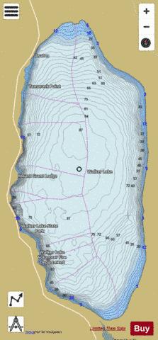
Walker Lake Fishing Map Stats | |
| Title | Walker Lake |
| Scale | 1:12000 |
| Counties | Mineral |
| Nearby Cities | Walker Lake, Babbitt, Thorne, Hawthorne, Schurz, Yerington, Weed Heights, Luning, Smith, Wabuska |
| Area * | 31615.40 acres |
| Shoreline * | 30.37 miles |
| Min Longitude | -118.77 |
| Min Latitude | 38.61 |
| Max Longitude | -118.67 |
| Max Latitude | 38.78 |
| Edition Label 1 | |
| Edition Label 2 | |
| Edition Label 3 | |
| Id | US_NV_00844615 |
| Country | US |
| Projection | Mercator |
| * some Stats may include nearby/connecting waterbodies | |
|