Lake Red Rock/Roberts Creek fishing map is available as part of iBoating : USA Marine & Fishing App(now supported on multiple platforms including Android, iPhone/iPad, MacBook, and Windows(tablet and phone)/PC based chartplotter.).
With our Lake Maps App, you get all the great marine chart app features like fishing spots, along with Lake Red Rock/Roberts Creek depth map. The fishing maps app include HD lake depth contours, along with advanced features found in Fish Finder / Gps Chart Plotter systems, turning your device into a Depth Finder. The Lake Red Rock/Roberts Creek Navigation App provides advanced features of a Marine Chartplotter including adjusting water level offset and custom depth shading. Fishing spots and depth contours layers are available in most Lake maps. Lake navigation features include advanced instrumentation to gather wind speed direction, water temperature, water depth, and accurate GPS with AIS receivers(using NMEA over TCP/UDP). Autopilot support can be enabled during ‘Goto WayPoint’ and ‘Route Assistance’.
Now i-Boating supports Fishing Points in Lake Red Rock/Roberts Creek.
Have more questions about the Nautical Chart App? Ask us.
Fishing Info for Lake Red Rock/Roberts Creek
Lake Red Rock, also referred to as Red Rock Reservoir is a reservoir formed by Red Rock Dam on the Des Moines River, about 41 miles southeast of the city of Des Moines, Iowa, U.S. The dam was completed in 1969 as a Flood control project by the United States Army Corps of Engineers, creating the largest lake in Iowa. The lake is essentially confined to Marion County. The damface is a few miles west and south of Pella, and similarly, a few miles northeast of Knoxville.
More on Wikipedia...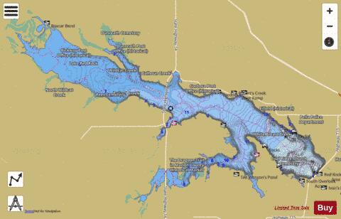
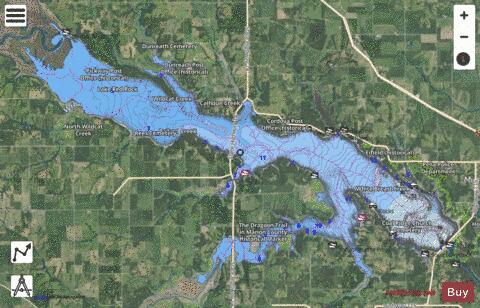
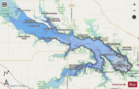
Lake Red Rock/Roberts Creek Fishing Map Stats | |
| Title | Lake Red Rock/Roberts Creek |
| Scale | 1:12000 |
| Counties | Marion |
| Nearby Cities | Knoxville, Otley, Pella, Pleasantville, Swan, Harvey, Monroe, Attica, Prairie City, Runnells |
| Area * | 15399.87 acres |
| Shoreline * | 86.75 miles |
| Min Longitude | -93.24 |
| Min Latitude | 41.35 |
| Max Longitude | -92.97 |
| Max Latitude | 41.47 |
| Edition Label 1 | |
| Edition Label 2 | |
| Edition Label 3 | |
| Id | US_IA_red_rock_lake |
| Country | US |
| Projection | Mercator |
| * some Stats may include nearby/connecting waterbodies | |
|