Lake Conway fishing map is available as part of iBoating : USA Marine & Fishing App(now supported on multiple platforms including Android, iPhone/iPad, MacBook, and Windows(tablet and phone)/PC based chartplotter.).
With our Lake Maps App, you get all the great marine chart app features like fishing spots, along with Lake Conway depth map. The fishing maps app include HD lake depth contours, along with advanced features found in Fish Finder / Gps Chart Plotter systems, turning your device into a Depth Finder. The Lake Conway Navigation App provides advanced features of a Marine Chartplotter including adjusting water level offset and custom depth shading. Fishing spots and depth contours layers are available in most Lake maps. Lake navigation features include advanced instrumentation to gather wind speed direction, water temperature, water depth, and accurate GPS with AIS receivers(using NMEA over TCP/UDP). Autopilot support can be enabled during ‘Goto WayPoint’ and ‘Route Assistance’.
Now i-Boating supports Fishing Points in Lake Conway.
Have more questions about the Nautical Chart App? Ask us.
Fishing Info for Lake Conway
Lake Conway is a 6,700-acre (27 km2) lake in Arkansas. Lake Conway is the largest lake ever created by a state wildlife commission and the first to be created by the Arkansas Game and Fish Commission. Lake Conway is located directly east of Mayflower, Arkansas, and just a few miles southeast of Conway, Arkansas. Lake Conway is home to many major sportfish such as bass, bluegill, crappie, blue catfish, and flathead catfish. Lake Conway's average depth is 4.5 ft and at its deepest point 16 ft. Lake Conway was constructed in 1948.The lake was created by damming Palarm Creek.
More on Wikipedia...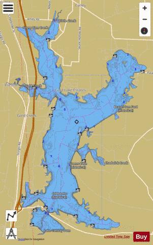
Lake Conway Fishing Map Stats | |
| Title | Lake Conway |
| Scale | 1:12000 |
| Counties | Faulkner |
| Nearby Cities | Mayflower, Conway, Maumelle, Marche, Roland, Cato, Natural Steps, Vilonia, Gibson, Wooster |
| Area * | 5449.52 acres |
| Shoreline * | 57.70 miles |
| Min Longitude | -92.43 |
| Min Latitude | 34.96 |
| Max Longitude | -92.35 |
| Max Latitude | 35.06 |
| Edition Label 1 | |
| Edition Label 2 | |
| Edition Label 3 | |
| Id | US_AR_00075680 |
| Country | US |
| Projection | Mercator |
| * some Stats may include nearby/connecting waterbodies | |
|