Lake Burton fishing map is available as part of iBoating : USA Marine & Fishing App(now supported on multiple platforms including Android, iPhone/iPad, MacBook, and Windows(tablet and phone)/PC based chartplotter.).
With our Lake Maps App, you get all the great marine chart app features like fishing spots, along with Lake Burton depth map. The fishing maps app include HD lake depth contours, along with advanced features found in Fish Finder / Gps Chart Plotter systems, turning your device into a Depth Finder. The Lake Burton Navigation App provides advanced features of a Marine Chartplotter including adjusting water level offset and custom depth shading. Fishing spots and depth contours layers are available in most Lake maps. Lake navigation features include advanced instrumentation to gather wind speed direction, water temperature, water depth, and accurate GPS with AIS receivers(using NMEA over TCP/UDP). Autopilot support can be enabled during ‘Goto WayPoint’ and ‘Route Assistance’.
Have more questions about the Nautical Chart App? Ask us.
Fishing Info for Lake Burton
Lake Burton is a 2,775 acre (11.23 km²) reservoir with 62 miles (100 km) of shoreline located in the northeastern corner of Georgia in Rabun County. The lake is owned and administered by the Georgia Power/Southern Company, but it is a public lake. Noted for the remarkable clarity of its water and surrounded by the biodiverse ecosystem of the Blue Ridge Mountains, the lake celebrated its centennial in 2020.
More on Wikipedia...Popular fish species in this lake include Black crappie, Largemouth bass, Rainbow trout, Redear sunfish, Spotted bass, Walleye, White bass and Yellow perch.
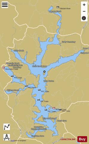

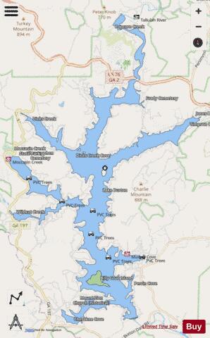
Lake Burton Fishing Map Stats | |
| Title | Lake Burton |
| Scale | 1:12000 |
| Counties | Rabun |
| Nearby Cities | Tiger, Tate City, Clayton, Lakemont, Mountain City, Turnerville, Tallulah Falls, Dillard, Hollywood, Clarkesville |
| Area * | 2527.78 acres |
| Shoreline * | 57.85 miles |
| Min Longitude | -83.59 |
| Min Latitude | 34.79 |
| Max Longitude | -83.51 |
| Max Latitude | 34.89 |
| Edition Label 1 | |
| Edition Label 2 | |
| Edition Label 3 | |
| Id | US_AA_GA_00327303 |
| Country | US |
| Projection | Mercator |
| * some Stats may include nearby/connecting waterbodies | |
|