Moyie Lake fishing map is included in Lakes and Rivers of British Columbia nautical charts folio. It is available as part of iBoating : Canada Marine & Fishing App (now supported on multiple platforms including Android, iPhone/iPad, MacBook, and Windows(tablet and phone)/PC based chartplotter. ).
With our Lake Maps App, you get all the great marine chart app features like fishing spots, along with Moyie Lake depth map. The fishing maps app include HD lake depth contours, along with advanced features found in Fish Finder / Gps Chart Plotter systems, turning your device into a Depth Finder. The Moyie Lake Navigation App provides advanced features of a Marine Chartplotter including adjusting water level offset and custom depth shading. Fishing spots and depth contours layers are available in most Lake maps. Lake navigation features include advanced instrumentation to gather wind speed direction, water temperature, water depth, and accurate GPS with AIS receivers(using NMEA over TCP/UDP). Autopilot support can be enabled during ‘Goto WayPoint’ and ‘Route Assistance’.
Now i-Boating supports Fishing Points in Moyie Lake.
Have more questions about the Nautical Chart App? Ask us.
Fishing Info for Moyie Lake
Moyie Lake is a small, narrow kettle lake in southern British Columbia, located along the Moyie River. While building the Crowsnest Pass Railroad, this was the hardest part to build the tracks. The walls of the land around it are very steep and short. It is a lot like Swan Lake to the south in Montana. The lake is located between Cranbrook and Creston. The small town of Moyie is located at the south end of the lake. Located 20 kilometres south of Cranbrook off Highway 3, Moyie Lake Provincial Park day-use area, boat launch, and 111 site campground provides the only public access to the deep blue mountain waters of Moyie Lake.
More on Wikipedia...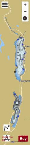
Moyie Lake Fishing Map Stats | |
| Title | Moyie Lake |
| Scale | 1:24000 |
| Districts | East Kootenay |
| Nearby Cities | Cranbrook, Kimberley, Creston, Fernie |
| Area * | 2310.08 acres |
| Shoreline * | 25.42 miles |
| Min Longitude | -115.86 |
| Min Latitude | 49.26 |
| Max Longitude | -115.82 |
| Max Latitude | 49.40 |
| Edition Label 1 | |
| Edition Label 2 | |
| Edition Label 3 | |
| Id | CA_BC_moyie_lake__bc |
| Country | CA |
| Projection | Mercator |
| * some Stats may include nearby/connecting waterbodies | |
|