Trout Lake fishing map is available as part of iBoating : USA Marine & Fishing App(now supported on multiple platforms including Android, iPhone/iPad, MacBook, and Windows(tablet and phone)/PC based chartplotter.).
With our Lake Maps App, you get all the great marine chart app features like fishing spots, along with Trout Lake depth map. The fishing maps app include HD lake depth contours, along with advanced features found in Fish Finder / Gps Chart Plotter systems, turning your device into a Depth Finder. The Trout Lake Navigation App provides advanced features of a Marine Chartplotter including adjusting water level offset and custom depth shading. Fishing spots and depth contours layers are available in most Lake maps. Lake navigation features include advanced instrumentation to gather wind speed direction, water temperature, water depth, and accurate GPS with AIS receivers(using NMEA over TCP/UDP). Autopilot support can be enabled during ‘Goto WayPoint’ and ‘Route Assistance’.
Now i-Boating supports Fishing Points in Trout Lake.
Have more questions about the Nautical Chart App? Ask us.
Fishing Info for Trout Lake
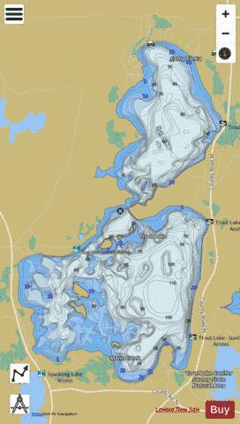
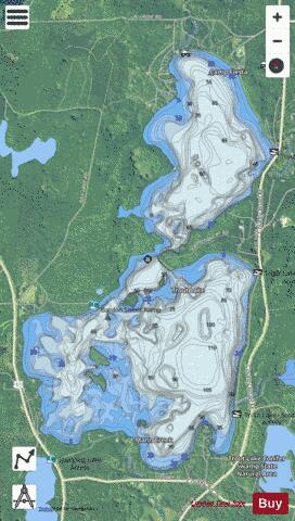
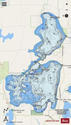
Trout Lake is in Vilas County, Wisconsin, near the towns of Boulder Junction and Arbor Vitae, Wisconsin. With a surface area of 6.208 sq mi (16.079 km2) and a volume of 0.058 cu mi (0.240 km3), Trout Lake is one of the largest lakes in Vilas County. It has 16.1 mi (25.9 km) of shoreline, a large portion of which is undeveloped. There are also seven islands within the lake: Miller Island, Zimmerman Island, Haunted Island, Easter Island, Fisk Island, Chocolate Drop Island, and an unnamed island. It is a dimictic eutrophic lake that is highly productive and supports a large number of sport fish, which has made it a popular angling destination.
More on Wikipedia...Popular fish species in this lake include Bowfin, Burbot, Cisco (fish), Lake trout, Lake whitefish, Largemouth bass, Northern pike, Rock bass, Smallmouth bass, Walleye and Yellow perch.
Trout Lake Fishing Map Stats | |
| Title | Trout Lake |
| Scale | 1:12000 |
| Counties | Vilas |
| Nearby Cities | Boulder Junction, Arbor Vitae, Woodruff, Sayner, Minocqua, Presque Isle, Lac du Flambeau, Saint Germain, Manitowish Waters, Lake Tomahawk |
| Area * | 3867.32 acres |
| Shoreline * | 20.17 miles |
| Min Longitude | -89.70 |
| Min Latitude | 46.01 |
| Max Longitude | -89.65 |
| Max Latitude | 46.08 |
| Edition Label 1 | |
| Edition Label 2 | |
| Edition Label 3 | |
| Id | US_WI_tr |
| Country | US |
| Projection | Mercator |
| * some Stats may include nearby/connecting waterbodies | |
|