Lake Willoughby fishing map is available as part of iBoating : USA Marine & Fishing App(now supported on multiple platforms including Android, iPhone/iPad, MacBook, and Windows(tablet and phone)/PC based chartplotter.).
With our Lake Maps App, you get all the great marine chart app features like fishing spots, along with Lake Willoughby depth map. The fishing maps app include HD lake depth contours, along with advanced features found in Fish Finder / Gps Chart Plotter systems, turning your device into a Depth Finder. The Lake Willoughby Navigation App provides advanced features of a Marine Chartplotter including adjusting water level offset and custom depth shading. Fishing spots and depth contours layers are available in most Lake maps. Lake navigation features include advanced instrumentation to gather wind speed direction, water temperature, water depth, and accurate GPS with AIS receivers(using NMEA over TCP/UDP). Autopilot support can be enabled during ‘Goto WayPoint’ and ‘Route Assistance’.
Now i-Boating supports Fishing Points in Lake Willoughby.
Have more questions about the Nautical Chart App? Ask us.
Fishing Info for Lake Willoughby
Lake Willoughby is a lake in the town of Westmore in Orleans County in the Northeast Kingdom of Vermont, United States. The lake's southern end is surrounded by the Willoughby State Forest. This state forest includes Mount Pisgah, Mount Hor, collectively "Willoughby Gap". In 2010, Yankee magazine named Willoughby as the third best lake in New England. Willoughby Lake has a public beach that stretches 0.4 kilometres (0.25 mi) on the north shore of the lake, or in the zone of the lake outlet. Another public beach is located at the bottom of the South Bay of the Lake. The village of Westmore is located on the east side, at the confluence area of Mill Creek which drains the waters of Long Pond. Many cottages and houses are located on North-East bank of the lake.
More on Wikipedia...Popular fish species in this lake include Atlantic salmon, Burbot, Common shiner, Lake chub, Longnose sucker, Rainbow smelt, Rainbow trout, White sucker and Yellow perch.
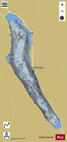
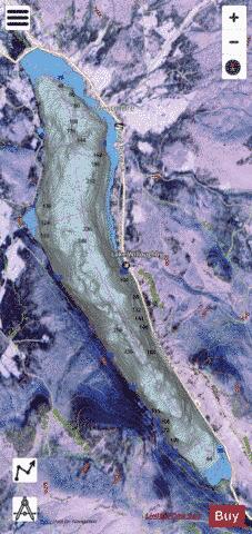
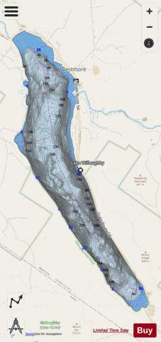
Lake Willoughby Fishing Map Stats | |
| Title | Lake Willoughby |
| Scale | 1:3000 |
| Counties | Orleans |
| Nearby Cities | Westmore, Sutton, West Burke, Barton, Glover, Wheelock, Sheffield, Morgan, East Haven, East Burke |
| Area * | 1733.66 acres |
| Shoreline * | 11.34 miles |
| Min Longitude | -72.07 |
| Min Latitude | 44.72 |
| Max Longitude | -72.03 |
| Max Latitude | 44.78 |
| Edition Label 1 | |
| Edition Label 2 | |
| Edition Label 3 | |
| Id | US_VT_01460283 |
| Country | US |
| Projection | Mercator |
| * some Stats may include nearby/connecting waterbodies | |
|