Lewis and Clark Lake fishing map is available as part of iBoating : USA Marine & Fishing App(now supported on multiple platforms including Android, iPhone/iPad, MacBook, and Windows(tablet and phone)/PC based chartplotter.).
With our Lake Maps App, you get all the great marine chart app features like fishing spots, along with Lewis and Clark Lake depth map. The fishing maps app include HD lake depth contours, along with advanced features found in Fish Finder / Gps Chart Plotter systems, turning your device into a Depth Finder. The Lewis and Clark Lake Navigation App provides advanced features of a Marine Chartplotter including adjusting water level offset and custom depth shading. Fishing spots and depth contours layers are available in most Lake maps. Lake navigation features include advanced instrumentation to gather wind speed direction, water temperature, water depth, and accurate GPS with AIS receivers(using NMEA over TCP/UDP). Autopilot support can be enabled during ‘Goto WayPoint’ and ‘Route Assistance’.
Now i-Boating supports Fishing Points in Lewis and Clark Lake.
Have more questions about the Nautical Chart App? Ask us.
Fishing Info for Lewis and Clark Lake
Lewis and Clark Lake is a 31,400 acre (130 km²) reservoir located on the border of the U.S. states of Nebraska and South Dakota on the Missouri River. The lake is approximately 25 miles (40 km) in length with over 90 miles (140 km) of shoreline and a maximum water depth of 45 feet (14 m). The lake is impounded by Gavins Point Dam and is managed by the U.S. Army Corps of Engineers, Omaha District.
More on Wikipedia...Popular fish species in this lake include Black bullhead, Common carp, Northern pike, Paddlefish, Sauger, Smallmouth bass, Walleye and Yellow perch.
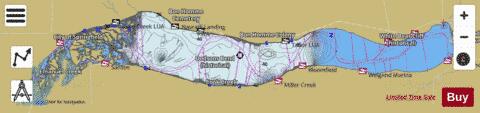
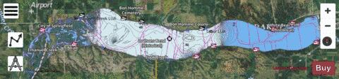
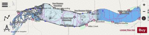
Lewis and Clark Lake Fishing Map Stats | |
| Title | Lewis and Clark Lake |
| Scale | 1:24000 |
| Counties | Cedar, Knox, Bon Homme, Yankton |
| Nearby Cities | Santee, Bon Homme Colony, Springfield, Aten, Running Water, Yankton, Tabor, Lindy, Utica, Crofton |
| Area * | 25203.06 acres |
| Shoreline * | 212.81 miles |
| Min Longitude | -97.92 |
| Min Latitude | 42.81 |
| Max Longitude | -97.48 |
| Max Latitude | 42.88 |
| Edition Label 1 | |
| Edition Label 2 | |
| Edition Label 3 | |
| Id | US_UB_SD_00830688 |
| Country | US |
| Projection | Mercator |
| * some Stats may include nearby/connecting waterbodies | |
|