Canandaigua Lake fishing map is available as part of iBoating : USA Marine & Fishing App(now supported on multiple platforms including Android, iPhone/iPad, MacBook, and Windows(tablet and phone)/PC based chartplotter.).
With our Lake Maps App, you get all the great marine chart app features like fishing spots, along with Canandaigua Lake depth map. The fishing maps app include HD lake depth contours, along with advanced features found in Fish Finder / Gps Chart Plotter systems, turning your device into a Depth Finder. The Canandaigua Lake Navigation App provides advanced features of a Marine Chartplotter including adjusting water level offset and custom depth shading. Fishing spots and depth contours layers are available in most Lake maps. Lake navigation features include advanced instrumentation to gather wind speed direction, water temperature, water depth, and accurate GPS with AIS receivers(using NMEA over TCP/UDP). Autopilot support can be enabled during ‘Goto WayPoint’ and ‘Route Assistance’.
Now i-Boating supports Fishing Points in Canandaigua Lake.
Have more questions about the Nautical Chart App? Ask us.
Fishing Info for Canandaigua Lake
Canandaigua Lake /ˌkænənˈdeɪɡwə/ is the fourth largest of the Finger Lakes in the U.S. state of New York. The City of Canandaigua is located at the northern end of the lake and the village of Naples is several miles south of the southern end. It is the westernmost of the major Finger Lakes. The name Canandaigua is derived from the Seneca name spelled variously Kanandarque, Ganondagan, Ga-nun-da-gwa, or in a modern transcription, tganǫdæ:gwęh, which means "the chosen spot", or "at the chosen town".
More on Wikipedia...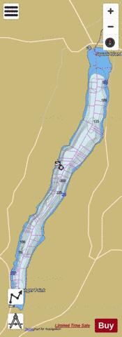
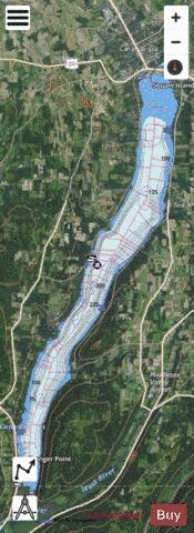
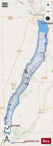
Canandaigua Lake Fishing Map Stats | |
| Title | Canandaigua Lake |
| Sailing Clubs in this Chart region | |
| Canandaigua Yacht Club | |
| Scale | 1:12000 |
| Counties | Ontario, Yates |
| Nearby Cities | Crystal Beach, Canandaigua, South Bristol, Rushville, Middlesex, Naples, Shortsville, Italy, Manchester, Potter |
| Area * | 10528.32 acres |
| Shoreline * | 40.95 miles |
| Min Longitude | -77.37 |
| Min Latitude | 42.66 |
| Max Longitude | -77.25 |
| Max Latitude | 42.89 |
| Edition Label 1 | |
| Edition Label 2 | |
| Edition Label 3 | |
| Id | US_UB_NY_00945740 |
| Country | US |
| Projection | Mercator |
| * some Stats may include nearby/connecting waterbodies | |
|