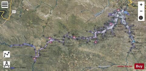
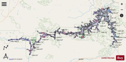
Fort Peck Lake fishing map is available as part of iBoating : USA Marine & Fishing App(now supported on multiple platforms including Android, iPhone/iPad, MacBook, and Windows(tablet and phone)/PC based chartplotter.).
With our Lake Maps App, you get all the great marine chart app features like fishing spots, along with Fort Peck Lake depth map. The fishing maps app include HD lake depth contours, along with advanced features found in Fish Finder / Gps Chart Plotter systems, turning your device into a Depth Finder. The Fort Peck Lake Navigation App provides advanced features of a Marine Chartplotter including adjusting water level offset and custom depth shading. Fishing spots and depth contours layers are available in most Lake maps. Lake navigation features include advanced instrumentation to gather wind speed direction, water temperature, water depth, and accurate GPS with AIS receivers(using NMEA over TCP/UDP). Autopilot support can be enabled during ‘Goto WayPoint’ and ‘Route Assistance’.
Now i-Boating supports Fishing Points in Fort Peck Lake.
Have more questions about the Nautical Chart App? Ask us.
Fishing Info for Fort Peck Lake
Fort Peck Lake, or Lake Fort Peck, is a major reservoir in Montana, formed by the Fort Peck Dam on the Missouri River. The lake lies in the eastern prairie region of Montana approximately 140 miles (230 km) east of Great Falls and 120 miles (190 km) north of Billings, reaching into portions of six counties. The dam and reservoir were built in the 1930s to enhance navigation on the Missouri River, supplying enough water downstream of the dam to provide for a 9-foot deep, 300-foot wide navigation channel from Sioux City, Iowa, to the mouth of the Missouri just above St. Louis. Following severe flooding along the Missouri River in 1943, which hampered the economic development of the Missouri River Valley and damaged production of military supplies for then-ongoing World War II, five additional dams were added when the federal government adopted the Pick-Sloan Plan, calling for a series of dams and reservoirs to be built along the Missouri and its tributaries. Fort Peck Dam was built from 1933 to 1940 by the U.S. Army Corps of Engineers; water impoundment began in 1937 and the reservoir was first filled to capacity in 1947. With a volume of 18,700,000 acre-feet (23.1 km3) when full, Fort Peck is the fifth largest artificial lake in the United States. It extends 134 miles (216 km) through central Montana, and its twisting, inlet-studded shoreline has a total length of some 1,520 miles (2,450 km). Along with the Missouri River, smaller tributaries such as the Musselshell River, Fourchette Creek, Timber Creek, Hell Creek and Dry Creek feed the reservoir; the latter forms the longest side arm of the reservoir, which reaches some 30 miles (48 km) southwards. The lake covers an area of 245,000 acres (99,000 ha), making it the largest in Montana by surface area, although Flathead Lake has a larger volume due to its greater depth. The reservoir is also a tourist attraction, with 27 designated recreational sites bordering its shores. Bordering nearly the entire reservoir is the 1,719-square-mile (4,450 km2) Charles M. Russell National Wildlife Refuge, which has preserved much of the high prairie and hill country around the lake. The lake is featured in the film Jurassic Park III, as part of an excavation.
More on Wikipedia...Popular fish species in this lake include Black bullhead, Black crappie, Brook stickleback, Burbot, Cisco (fish), Etheostoma exile, Fathead minnow, Freshwater drum, Fundulus zebrinus, Goldeye, Green sunfish, Lake chub, Lake trout, Lake whitefish, Largemouth bass, Longnose dace, Longnose sucker, Northern pike, Northern redbelly dace, Noturus flavus, Paddlefish, Rainbow trout, River carpsucker, Sauger, Semotilus, Smallmouth bass, Walleye, White crappie, White sucker and Yellow perch.
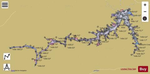
Fort Peck Lake Fishing Map Stats | |
| Title | Fort Peck Lake |
| Scale | 1:48000 |
| Counties | Fergus, Garfield, McCone, Petroleum, Phillips, Valley |
| Nearby Cities | Fort Peck, Wheeler, Park Grove, Nashua, Sun Prairie, Glasgow, Brusett, Valentine, Jordan, Frazer |
| Area * | 233295.81 acres |
| Shoreline * | 1535.40 miles |
| Min Longitude | -108.36 |
| Min Latitude | 47.37 |
| Max Longitude | -106.18 |
| Max Latitude | 48.02 |
| Edition Label 1 | |
| Edition Label 2 | |
| Edition Label 3 | |
| Id | US_UB_MT_00771516 |
| Country | US |
| Projection | Mercator |
| * some Stats may include nearby/connecting waterbodies | |
|