Canyon fishing map is available as part of iBoating : USA Marine & Fishing App(now supported on multiple platforms including Android, iPhone/iPad, MacBook, and Windows(tablet and phone)/PC based chartplotter.).
With our Lake Maps App, you get all the great marine chart app features like fishing spots, along with Canyon lake depth map. The fishing maps app include HD lake depth contours, along with advanced features found in Fish Finder / Gps Chart Plotter systems, turning your device into a Depth Finder. The Canyon Navigation App provides advanced features of a Marine Chartplotter including adjusting water level offset and custom depth shading. Fishing spots and depth contours layers are available in most Lake maps. Lake navigation features include advanced instrumentation to gather wind speed direction, water temperature, water depth, and accurate GPS with AIS receivers(using NMEA over TCP/UDP). Autopilot support can be enabled during ‘Goto WayPoint’ and ‘Route Assistance’.
Now i-Boating supports Fishing Points in Canyon.
Have more questions about the Nautical Chart App? Ask us.
Fishing Info for Canyon
Canyon Lake is a reservoir on the Guadalupe River in the Texas Hill Country in the United States. Canyon Lake is a U.S. Army Corps of Engineers reservoir formed on the Guadalupe River in Comal County by Canyon Dam, which is located about sixteen miles northwest of New Braunfels. The dam, lake, and all adjacent property are managed by the U.S. Army Corps Of Engineers. Water rights, waste water treatment, and hydroelectric generating facilities are managed by the Guadalupe-Blanco River Authority. Construction of the dam began in 1958 and was completed in 1964. The reservoir serves to provide flood control and water supply for the communities downstream from the dam. The lake is also a popular recreational destination.
More on Wikipedia...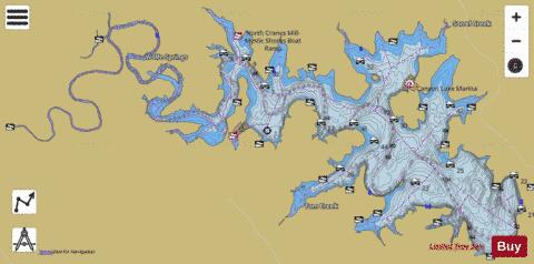
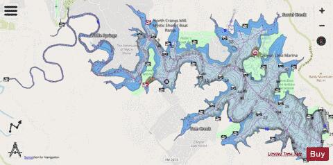
Canyon Fishing Map Stats | |
| Title | Canyon |
| Sailing Clubs in this Chart region | |
| Hill Country Yacht Club | |
| Lake Canyon Yacht Club | |
| Scale | 1:12000 |
| Counties | Comal |
| Nearby Cities | Canyon Lake, Spring Branch, Fischer, Wimberley, Gruene, Woodcreek, Bulverde, New Braunfels, Dittlinger, Hunter |
| Area * | 8309.74 acres |
| Shoreline * | 95.92 miles |
| Min Longitude | -98.37 |
| Min Latitude | 29.85 |
| Max Longitude | -98.20 |
| Max Latitude | 29.92 |
| Edition Label 1 | |
| Edition Label 2 | |
| Edition Label 3 | |
| Id | US_TX_canyon |
| Country | US |
| Projection | Mercator |
| * some Stats may include nearby/connecting waterbodies | |
|