Kampeska fishing map is available as part of iBoating : USA Marine & Fishing App(now supported on multiple platforms including Android, iPhone/iPad, MacBook, and Windows(tablet and phone)/PC based chartplotter.).
With our Lake Maps App, you get all the great marine chart app features like fishing spots, along with Kampeska lake depth map. The fishing maps app include HD lake depth contours, along with advanced features found in Fish Finder / Gps Chart Plotter systems, turning your device into a Depth Finder. The Kampeska Navigation App provides advanced features of a Marine Chartplotter including adjusting water level offset and custom depth shading. Fishing spots and depth contours layers are available in most Lake maps. Lake navigation features include advanced instrumentation to gather wind speed direction, water temperature, water depth, and accurate GPS with AIS receivers(using NMEA over TCP/UDP). Autopilot support can be enabled during ‘Goto WayPoint’ and ‘Route Assistance’.
Now i-Boating supports Fishing Points in Kampeska.
Have more questions about the Nautical Chart App? Ask us.
Fishing Info for Kampeska
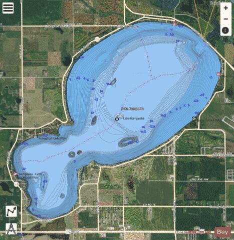
Lake Kampeska is a 5,250-acre (21 km2) inland glacial lake in the U.S. state of South Dakota. It is located west-northwest of Watertown, South Dakota and lies entirely within Codington County and the Coteau des Prairies. The lake is naturally shaped and the most urban developed lake in South Dakota with approximately 13.5 miles (20 km) of residential shoreline. Lake Kampeska is connected to the Big Sioux River through a single inlet-outlet channel located on the northeast side. It is the third largest natural lake within the borders of South Dakota. Lake Kampeska is well-known for its depictions in art from wildlife and nature artists such as Terry Redlin, John Greene, John Wilson, and Joshua Spies. Lake Kampeska is perhaps featured most prominently in the artworks of Terry Redlin and are displayed in the Redlin Art Center nearby in Watertown, South Dakota.It is located in the north near the grainery.
More on Wikipedia...Popular fish species in this lake include Black bullhead, Black crappie, Lake sturgeon, Northern pike, Pumpkinseed, Rock bass, Smallmouth bass, Walleye, White bass, White crappie, White sucker, Yellow bullhead and Yellow perch.
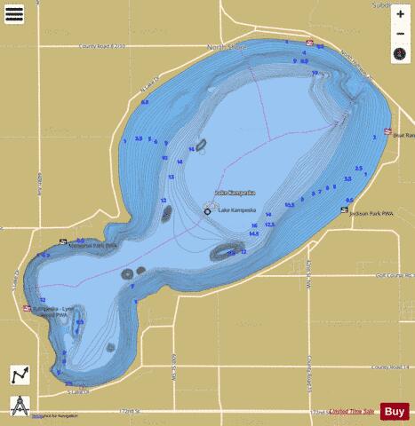
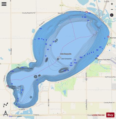
Kampeska Fishing Map Stats | |
| Title | Kampeska |
| Scale | 1:24000 |
| Counties | Codington |
| Nearby Cities | Watertown, Florence, Hazel, Waverly, Henry, Hayti, Castlewood, Kranzburg, Wallace, Naples |
| Area * | 4988.68 acres |
| Shoreline * | 13.07 miles |
| Min Longitude | -97.25 |
| Min Latitude | 44.89 |
| Max Longitude | -97.17 |
| Max Latitude | 44.95 |
| Edition Label 1 | |
| Edition Label 2 | |
| Edition Label 3 | |
| Id | US_SD_kampeska_codington_sd |
| Country | US |
| Projection | Mercator |
| * some Stats may include nearby/connecting waterbodies | |
|