Henry fishing map is available as part of iBoating : USA Marine & Fishing App(now supported on multiple platforms including Android, iPhone/iPad, MacBook, and Windows(tablet and phone)/PC based chartplotter.).
With our Lake Maps App, you get all the great marine chart app features like fishing spots, along with Henry lake depth map. The fishing maps app include HD lake depth contours, along with advanced features found in Fish Finder / Gps Chart Plotter systems, turning your device into a Depth Finder. The Henry Navigation App provides advanced features of a Marine Chartplotter including adjusting water level offset and custom depth shading. Fishing spots and depth contours layers are available in most Lake maps. Lake navigation features include advanced instrumentation to gather wind speed direction, water temperature, water depth, and accurate GPS with AIS receivers(using NMEA over TCP/UDP). Autopilot support can be enabled during ‘Goto WayPoint’ and ‘Route Assistance’.
Now i-Boating supports Fishing Points in Henry.
Have more questions about the Nautical Chart App? Ask us.
Fishing Info for Henry
Lake Henry is a small artificial lake formed by the construction of a dam across in Bon Homme County, South Dakota, United States, about 0.75 mi (1.21 km) east of the town of Scotland. The lake is within the James River watershed. The lake was named in honor of State Senator Henry Brown of Bon Homme County. The original dam was constructed in 1937. By the late 1980s, however, decades of erosion had degraded the lake and use had declined considerably. Plans to renovate the lake began in 1991 after extensive damage to the spillway was discovered. In 1994, the dam was breached and the lake drained to allow spillway repairs and the removal of accumulated sediments. The renovation project quickly ground to a halt when funding was withdrawn and the lake remained dry for nearly a decade. In 2002, funding for the project was restored. It was determined more economical to build a new dam rather than rebuild the old one. A new site was chosen ⅜ of a mile downstream and construction began late in 2002. The dam was completed in 2003 and completely filled with water in 2005. The lake is popular for fishing and recreation in the area. The lake is stocked by the South Dakota Department of Game, Fish, and Parks. Fish species found at Lake Henry include: largemouth bass, yellow perch, channel catfish, black crappie, bluegill, black bullhead, green sunfish, hybrid sunfish, white sucker, and carp. There is a boat ramp with dock on southeast corner with public restrooms. There are two handicapped accessible fishing piers. The entire lake is designated a "no wake zone".
More on Wikipedia...Popular fish species in this lake include Black bullhead, Black crappie, Green sunfish, Largemouth bass, White sucker and Yellow perch.
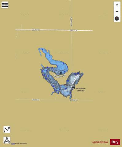
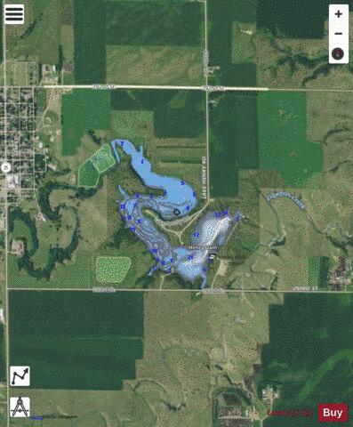

Henry Fishing Map Stats | |
| Title | Henry |
| Scale | 1:6000 |
| Counties | Bon Homme |
| Nearby Cities | Scotland, Olivet, Kaylor, Lesterville, Menno, Tabor, Tyndall, Tschetter Colony, Utica, Tripp |
| Area * | 104.15 acres |
| Shoreline * | 4.26 miles |
| Min Longitude | -97.71 |
| Min Latitude | 43.14 |
| Max Longitude | -97.69 |
| Max Latitude | 43.15 |
| Edition Label 1 | |
| Edition Label 2 | |
| Edition Label 3 | |
| Id | US_SD_henry_bon_homme_sd |
| Country | US |
| Projection | Mercator |
| * some Stats may include nearby/connecting waterbodies | |
|