Tenmile Lake fishing map is available as part of iBoating : USA Marine & Fishing App(now supported on multiple platforms including Android, iPhone/iPad, MacBook, and Windows(tablet and phone)/PC based chartplotter.).
With our Lake Maps App, you get all the great marine chart app features like fishing spots, along with Tenmile Lake depth map. The fishing maps app include HD lake depth contours, along with advanced features found in Fish Finder / Gps Chart Plotter systems, turning your device into a Depth Finder. The Tenmile Lake Navigation App provides advanced features of a Marine Chartplotter including adjusting water level offset and custom depth shading. Fishing spots and depth contours layers are available in most Lake maps. Lake navigation features include advanced instrumentation to gather wind speed direction, water temperature, water depth, and accurate GPS with AIS receivers(using NMEA over TCP/UDP). Autopilot support can be enabled during ‘Goto WayPoint’ and ‘Route Assistance’.
Now i-Boating supports Fishing Points in Tenmile Lake.
Have more questions about the Nautical Chart App? Ask us.
Fishing Info for Tenmile Lake
Tenmile Lake is the largest and southernmost of a chain of lakes along the Oregon Coast south of the Umpqua River in the United States. The chain includes North Tenmile, Eel, Clear, and smaller lakes, which drain into the Pacific Ocean via Tenmile Creek. The lake is 8 miles (13 km) south of Reedsport and 0.5 miles (0.80 km) east of U.S. Route 101 near the community of Lakeside. Tenmile Lake is named after the creek, which is about 10 miles (16 km) south of Winchester Bay. This community, at the mouth of the Umpqua River, was the earliest pioneer village along this part of the coast. Although the lake's official name is Tenmile Lake, it was formerly called Johnson Lake and South Tenmile Lake.
More on Wikipedia...Popular fish species in this lake include Black crappie, Brown bullhead, Largemouth bass, Rainbow trout and Yellow perch.
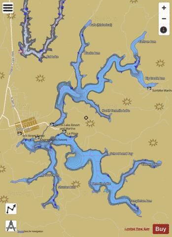
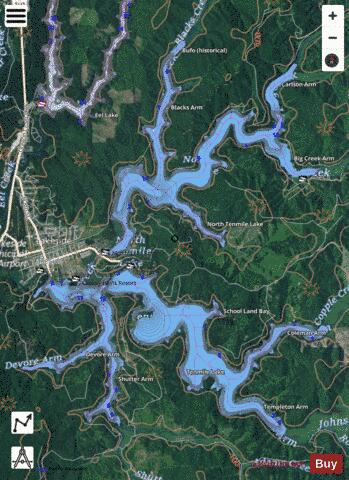
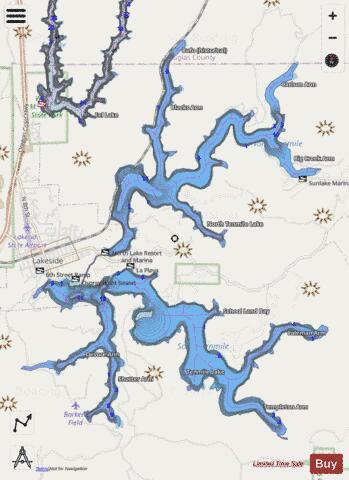
Tenmile Lake Fishing Map Stats | |
| Title | Tenmile Lake |
| Sailing Clubs in this Chart region | |
| Coos Bay Yacht Club | |
| Scale | 1:6000 |
| Counties | Coos, Douglas |
| Nearby Cities | Lakeside, Winchester Bay, Hauser, Reedsport, Gardiner, Glasgow, Allegany, North Bend, Coos Bay, Bunker Hill |
| Area * | 1977.61 acres |
| Shoreline * | 45.47 miles |
| Min Longitude | -124.18 |
| Min Latitude | 43.54 |
| Max Longitude | -124.11 |
| Max Latitude | 43.62 |
| Edition Label 1 | |
| Edition Label 2 | |
| Edition Label 3 | |
| Id | US_OR_ordfw_tenmile_lake |
| Country | US |
| Projection | Mercator |
| * some Stats may include nearby/connecting waterbodies | |
|