Malheur Reservoir fishing map is available as part of iBoating : USA Marine & Fishing App(now supported on multiple platforms including Android, iPhone/iPad, MacBook, and Windows(tablet and phone)/PC based chartplotter.).
With our Lake Maps App, you get all the great marine chart app features like fishing spots, along with Malheur Reservoir depth map. The fishing maps app include HD lake depth contours, along with advanced features found in Fish Finder / Gps Chart Plotter systems, turning your device into a Depth Finder. The Malheur Reservoir Navigation App provides advanced features of a Marine Chartplotter including adjusting water level offset and custom depth shading. Fishing spots and depth contours layers are available in most Lake maps. Lake navigation features include advanced instrumentation to gather wind speed direction, water temperature, water depth, and accurate GPS with AIS receivers(using NMEA over TCP/UDP). Autopilot support can be enabled during ‘Goto WayPoint’ and ‘Route Assistance’.
Now i-Boating supports Fishing Points in Malheur Reservoir.
Have more questions about the Nautical Chart App? Ask us.
Fishing Info for Malheur Reservoir
Malheur Reservoir is an irrigation lake along Willow Creek in Malheur County in the U.S. state of Oregon. Built by the Orchard Irrigation District in the 1930s, the 1,282-acre (5.19 km2) lake can hold about 49,000 acre-feet (60,000,000 m3) of water, which is used to irrigate about 2,300 acres (930 ha) of farmland downstream. Draining a semi-arid rangeland basin of 254 square miles (660 km2), the reservoir receives very high concentrations of nutrients and is naturally eutrophic. About 80 percent of the 12.3-mile (19.8 km) shoreline is privately owned, but the lake and part of the shore is open to public use. Since the mid-1960s, the reservoir has been stocked with rainbow trout, although fishing conditions have varied with weather cycles, and the reservoir has at times gone dry during drought. During wet cycles, it is capable of producing trout in excess of 20 inches (51 cm) long. The lake is accessible by dirt road, starting either from an intersection with U.S. Route 26, about 15 miles (24 km) to the southwest, near Ironside, or from a different intersection with Route 26, about 15 miles (24 km) to the southeast near Brogan. The lake has a boat ramp on the north shore, and camping is possible in a few places near the ramp. The Malheur County Parks Department maintains the boat ramp as well as gravel parking and a restroom.
More on Wikipedia...Popular fish species in this lake include Rainbow trout.
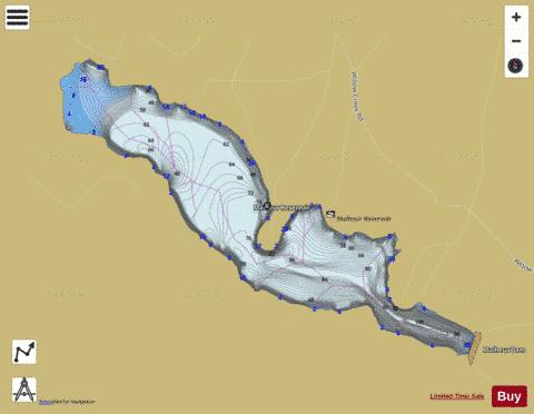
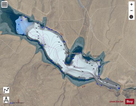

Malheur Reservoir Fishing Map Stats | |
| Title | Malheur Reservoir |
| Scale | 1:6000 |
| Counties | Malheur |
| Nearby Cities | Brogan, Ironside, Jamieson, Westfall, Lime, Huntington, Baker City, Unity, Harper, Keating |
| Area * | 320.02 acres |
| Shoreline * | 5.17 miles |
| Min Longitude | -117.70 |
| Min Latitude | 44.35 |
| Max Longitude | -117.67 |
| Max Latitude | 44.37 |
| Edition Label 1 | |
| Edition Label 2 | |
| Edition Label 3 | |
| Id | US_OR_ordfw_malheur_reservoir |
| Country | US |
| Projection | Mercator |
| * some Stats may include nearby/connecting waterbodies | |
|