Lava Lake fishing map is available as part of iBoating : USA Marine & Fishing App(now supported on multiple platforms including Android, iPhone/iPad, MacBook, and Windows(tablet and phone)/PC based chartplotter.).
With our Lake Maps App, you get all the great marine chart app features like fishing spots, along with Lava Lake depth map. The fishing maps app include HD lake depth contours, along with advanced features found in Fish Finder / Gps Chart Plotter systems, turning your device into a Depth Finder. The Lava Lake Navigation App provides advanced features of a Marine Chartplotter including adjusting water level offset and custom depth shading. Fishing spots and depth contours layers are available in most Lake maps. Lake navigation features include advanced instrumentation to gather wind speed direction, water temperature, water depth, and accurate GPS with AIS receivers(using NMEA over TCP/UDP). Autopilot support can be enabled during ‘Goto WayPoint’ and ‘Route Assistance’.
Now i-Boating supports Fishing Points in Lava Lake.
Have more questions about the Nautical Chart App? Ask us.
Fishing Info for Lava Lake
Lava Lake lies in the Cascade Range about 25 miles (40 km) west-southwest of Bend in the U.S. state of Oregon. It is a close neighbor of Little Lava Lake, from which it is separated by solidified lava. Lava Lake is at an elevation of 4,740 feet (1,440 m) in the Deschutes National Forest. The lake covers 368 acres (149 ha) to an average depth of 20 feet (6.1 m). Lava Lake, Little Lava Lake, and other nearby lakes are volcanogenic, having formed after lava flows from Mount Bachelor altered drainage patterns in the area. Solidified lava flows are visible along the shorelines of both lakes, and the volcanic peaks Broken Top and South Sister can be seen to the north.
More on Wikipedia...Popular fish species in this lake include Brook trout, Rainbow trout and Tui chub.
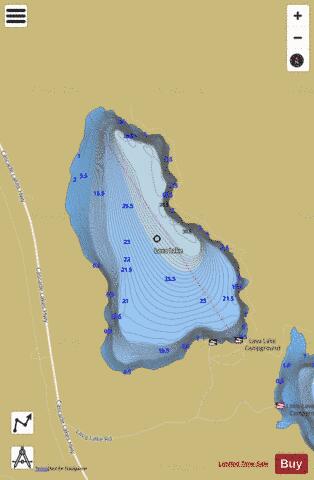
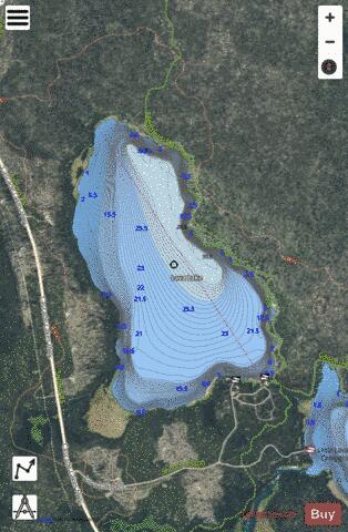
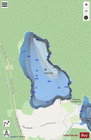
Lava Lake Fishing Map Stats | |
| Title | Lava Lake |
| Scale | 1:6000 |
| Counties | Deschutes |
| Nearby Cities | La Pine, Sisters, Gilchrist, Crescent Lake, Crescent, McKenzie Bridge, Bend, Tumalo, Camp Sherman, McCredie Springs |
| Area * | 343.08 acres |
| Shoreline * | 3.44 miles |
| Min Longitude | -121.78 |
| Min Latitude | 43.91 |
| Max Longitude | -121.76 |
| Max Latitude | 43.93 |
| Edition Label 1 | |
| Edition Label 2 | |
| Edition Label 3 | |
| Id | US_OR_ordfw_lava_lake |
| Country | US |
| Projection | Mercator |
| * some Stats may include nearby/connecting waterbodies | |
|