Hart Lake fishing map is available as part of iBoating : USA Marine & Fishing App(now supported on multiple platforms including Android, iPhone/iPad, MacBook, and Windows(tablet and phone)/PC based chartplotter.).
With our Lake Maps App, you get all the great marine chart app features like fishing spots, along with Hart Lake depth map. The fishing maps app include HD lake depth contours, along with advanced features found in Fish Finder / Gps Chart Plotter systems, turning your device into a Depth Finder. The Hart Lake Navigation App provides advanced features of a Marine Chartplotter including adjusting water level offset and custom depth shading. Fishing spots and depth contours layers are available in most Lake maps. Lake navigation features include advanced instrumentation to gather wind speed direction, water temperature, water depth, and accurate GPS with AIS receivers(using NMEA over TCP/UDP). Autopilot support can be enabled during ‘Goto WayPoint’ and ‘Route Assistance’.
Now i-Boating supports Fishing Points in Hart Lake.
Have more questions about the Nautical Chart App? Ask us.
Fishing Info for Hart Lake
Hart Lake is a shallow lake in the Warner Valley of eastern Lake County, Oregon, United States. The lake covers 7,324 acres (29.64 km2) and has the most stable water level within the valley's Warner Lakes chain. The lake is named for the heart-shaped brand used by the pioneer Wilson and Alexander cattle ranch established near the lake. Much of the land around Hart Lake is administered by the Bureau of Land Management (BLM) and the United States Fish and Wildlife Service (FWS). The lake and the surrounding wetlands support a wide variety of birds and other wildlife. Recreational opportunities on and near Hart Lake include hunting, fishing, bird watching, and boating.
More on Wikipedia...Popular fish species in this lake include Crappie, Rainbow trout, Smallmouth bass and Tui chub.
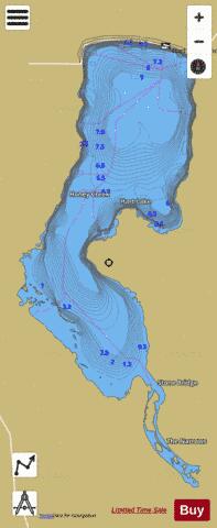
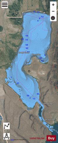
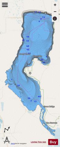
Hart Lake Fishing Map Stats | |
| Title | Hart Lake |
| Scale | 1:12000 |
| Counties | Lake |
| Nearby Cities | Plush, Adel, Valley Falls, Lakeview, New Pine Creek, New Pine Creek, Fort Bidwell, Willow Ranch, Paisley, Vya |
| Area * | 7501.09 acres |
| Shoreline * | 49.13 miles |
| Min Longitude | -119.89 |
| Min Latitude | 42.33 |
| Max Longitude | -119.82 |
| Max Latitude | 42.45 |
| Edition Label 1 | |
| Edition Label 2 | |
| Edition Label 3 | |
| Id | US_OR_ordfw_hart_lake |
| Country | US |
| Projection | Mercator |
| * some Stats may include nearby/connecting waterbodies | |
|