Cullaby Lake fishing map is available as part of iBoating : USA Marine & Fishing App(now supported on multiple platforms including Android, iPhone/iPad, MacBook, and Windows(tablet and phone)/PC based chartplotter.).
With our Lake Maps App, you get all the great marine chart app features like fishing spots, along with Cullaby Lake depth map. The fishing maps app include HD lake depth contours, along with advanced features found in Fish Finder / Gps Chart Plotter systems, turning your device into a Depth Finder. The Cullaby Lake Navigation App provides advanced features of a Marine Chartplotter including adjusting water level offset and custom depth shading. Fishing spots and depth contours layers are available in most Lake maps. Lake navigation features include advanced instrumentation to gather wind speed direction, water temperature, water depth, and accurate GPS with AIS receivers(using NMEA over TCP/UDP). Autopilot support can be enabled during ‘Goto WayPoint’ and ‘Route Assistance’.
Now i-Boating supports Fishing Points in Cullaby Lake.
Have more questions about the Nautical Chart App? Ask us.
Fishing Info for Cullaby Lake
Cullaby Lake is a lake near Warrenton, Oregon, United States. It is the central feature of Cullaby Lake County Park, and one of the major lakes of Clatsop Plains. Cullaby Lake's main water inflow is which flows in from the south and drains the coastal hills to the east of Clatsop Plains, Gearhart and Seaside. It has been the headwaters of the Skipanon River since the construction of the in the 1800s, before this, the lake drained to the south via into the Necanicum River north of Seaside. The park contains a boat ramp for the lake.
More on Wikipedia...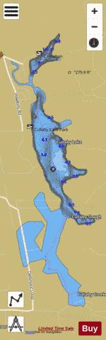
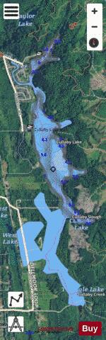
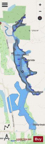
Cullaby Lake Fishing Map Stats | |
| Title | Cullaby Lake |
| Scale | 1:6000 |
| Counties | Clatsop |
| Nearby Cities | Gearhart, Warrenton, Seaside, Hammond, Astoria, Megler, Chinook, Cannon Beach, Arch Cape, Ilwaco |
| Area * | 343.04 acres |
| Shoreline * | 10.06 miles |
| Min Longitude | -123.91 |
| Min Latitude | 46.06 |
| Max Longitude | -123.89 |
| Max Latitude | 46.10 |
| Edition Label 1 | |
| Edition Label 2 | |
| Edition Label 3 | |
| Id | US_OR_ordfw_cullaby_lake |
| Country | US |
| Projection | Mercator |
| * some Stats may include nearby/connecting waterbodies | |
|