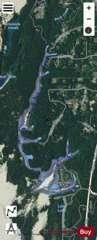
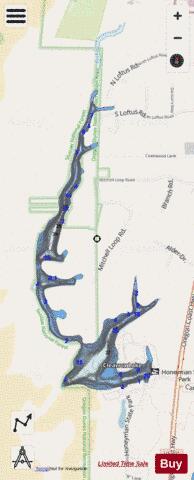
Cleawox Lake fishing map is available as part of iBoating : USA Marine & Fishing App(now supported on multiple platforms including Android, iPhone/iPad, MacBook, and Windows(tablet and phone)/PC based chartplotter.).
With our Lake Maps App, you get all the great marine chart app features like fishing spots, along with Cleawox Lake depth map. The fishing maps app include HD lake depth contours, along with advanced features found in Fish Finder / Gps Chart Plotter systems, turning your device into a Depth Finder. The Cleawox Lake Navigation App provides advanced features of a Marine Chartplotter including adjusting water level offset and custom depth shading. Fishing spots and depth contours layers are available in most Lake maps. Lake navigation features include advanced instrumentation to gather wind speed direction, water temperature, water depth, and accurate GPS with AIS receivers(using NMEA over TCP/UDP). Autopilot support can be enabled during ‘Goto WayPoint’ and ‘Route Assistance’.
Now i-Boating supports Fishing Points in Cleawox Lake.
Have more questions about the Nautical Chart App? Ask us.
Fishing Info for Cleawox Lake
Cleawox Lake (klē' ə woks), is a body of water dammed by sand dunes along the Pacific Ocean coast of the U.S. state of Oregon. The lake is about 3 miles (5 km) south of Florence along U.S. Route 101. Sharing the lakeshore are private properties as well as Oregon Dunes National Recreation Area and Jessie M. Honeyman Memorial State Park, which also partly fronts on Woahink Lake. Cleawox is derived from the Siuslaw name for the lake.
More on Wikipedia...Popular fish species in this lake include Rainbow trout.
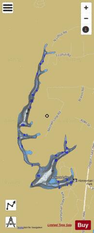
Cleawox Lake Fishing Map Stats | |
| Title | Cleawox Lake |
| Scale | 1:3000 |
| Counties | Lane |
| Nearby Cities | Florence, Dunes City, Siltcoos, Cushman, Gardiner, Reedsport, Winchester Bay, Mapleton, Swisshome, Lakeside |
| Area * | 76.57 acres |
| Shoreline * | 5.51 miles |
| Min Longitude | -124.12 |
| Min Latitude | 43.93 |
| Max Longitude | -124.11 |
| Max Latitude | 43.95 |
| Edition Label 1 | |
| Edition Label 2 | |
| Edition Label 3 | |
| Id | US_OR_ordfw_cleawox_lake |
| Country | US |
| Projection | Mercator |
| * some Stats may include nearby/connecting waterbodies | |
|