Kabekona fishing map is available as part of iBoating : USA Marine & Fishing App(now supported on multiple platforms including Android, iPhone/iPad, MacBook, and Windows(tablet and phone)/PC based chartplotter.).
With our Lake Maps App, you get all the great marine chart app features like fishing spots, along with Kabekona lake depth map. The fishing maps app include HD lake depth contours, along with advanced features found in Fish Finder / Gps Chart Plotter systems, turning your device into a Depth Finder. The Kabekona Navigation App provides advanced features of a Marine Chartplotter including adjusting water level offset and custom depth shading. Fishing spots and depth contours layers are available in most Lake maps. Lake navigation features include advanced instrumentation to gather wind speed direction, water temperature, water depth, and accurate GPS with AIS receivers(using NMEA over TCP/UDP). Autopilot support can be enabled during ‘Goto WayPoint’ and ‘Route Assistance’.
Now i-Boating supports Fishing Points in Kabekona.
Have more questions about the Nautical Chart App? Ask us.
Fishing Info for Kabekona
Kabekona Lake is a clear lake in northern Minnesota, United States, located 2.5 miles south of Laporte in Hubbard County. Kabekona has a surface area of 2,252 acres (9 km2) and a maximum depth of 133 feet (41 m). Kabekona (Gabekana in the Ojibwe language) means "End of the Trail" to dissuade others from venturing to the very clear lake. Kabekona is the 2nd clearest lake in Minnesota. This spring-fed lake is known for its loon birdlife. At one point it was thought to be the source of the Mississippi River. Among the most popular fishes in this lake are yellow perch, bass, northern pike, and walleye. Kabekona Lake was formerly known as "Friendship Springs". The best fishing spot on the lake is known as “Keay Point”, named after the family who lives close by.
More on Wikipedia...Popular fish species in this lake include Northern pike, Walleye and Yellow perch.
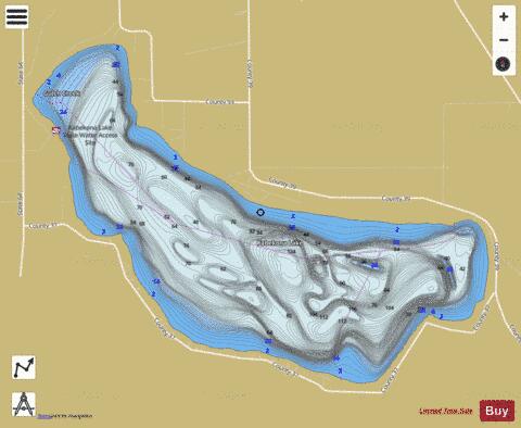
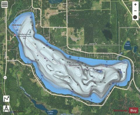
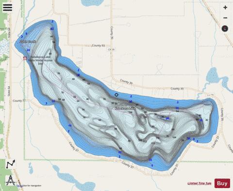
Kabekona Fishing Map Stats | |
| Title | Kabekona |
| Scale | 1:12000 |
| Counties | Hubbard |
| Nearby Cities | Benedict, Laporte, Guthrie, Wilkinson, Akeley, Walker, Lake George, Nevis, Cass Lake, Hackensack |
| Area * | 2434.28 acres |
| Shoreline * | 10.16 miles |
| Min Longitude | -94.79 |
| Min Latitude | 47.15 |
| Max Longitude | -94.72 |
| Max Latitude | 47.19 |
| Edition Label 1 | |
| Edition Label 2 | |
| Edition Label 3 | |
| Id | US_MN_29007500 |
| Country | US |
| Projection | Mercator |
| * some Stats may include nearby/connecting waterbodies | |
|