Christmas fishing map is available as part of iBoating : USA Marine & Fishing App(now supported on multiple platforms including Android, iPhone/iPad, MacBook, and Windows(tablet and phone)/PC based chartplotter.).
With our Lake Maps App, you get all the great marine chart app features like fishing spots, along with Christmas lake depth map. The fishing maps app include HD lake depth contours, along with advanced features found in Fish Finder / Gps Chart Plotter systems, turning your device into a Depth Finder. The Christmas Navigation App provides advanced features of a Marine Chartplotter including adjusting water level offset and custom depth shading. Fishing spots and depth contours layers are available in most Lake maps. Lake navigation features include advanced instrumentation to gather wind speed direction, water temperature, water depth, and accurate GPS with AIS receivers(using NMEA over TCP/UDP). Autopilot support can be enabled during ‘Goto WayPoint’ and ‘Route Assistance’.
Now i-Boating supports Fishing Points in Christmas.
Have more questions about the Nautical Chart App? Ask us.
Fishing Info for Christmas
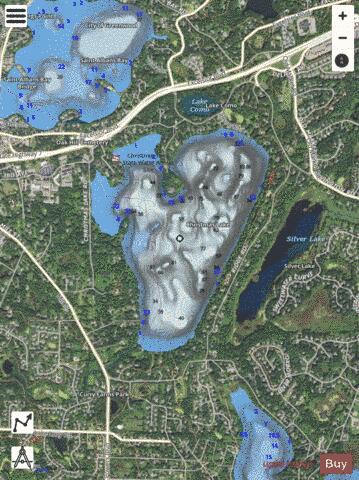
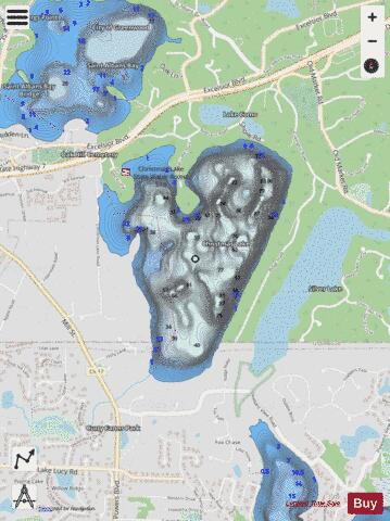
Christmas Lake is a spring-fed lake covering approximately 265 acres (1.1 km2) in the western Minneapolis suburbs of Shorewood and Chanhassen. The lake is crossed by the border of Hennepin and Carver counties, with most of the area lying within the jurisdiction of the former. Christmas Lake is known for its exceptional water clarity, the best in the Minneapolis metropolitan area, with a DNR-reported clarity level of 20 feet (6.10 m). This clarity can be attributed to the fact that Christmas Lake is a spring fed lake with a sandy bottom. Although relatively small in area, Christmas Lake becomes deep (its maximum depth is 87 ft (27 m)) very quickly, forming the basin of a depression that extends all along "the Ridge" (the rim of the lake's basin). The steep nature of the shoreline means that many houses are built far above the lake with railed motorized carts to provide access to the docks at the water level. Although Christmas Lake is located very near to the much larger and more populated Lake Minnetonka, the lake culture is much different, with fewer powerboats and jetskis, although this is slowly changing. Christmas Lake is connected to Lake Minnetonka by an underground canal which can be used to raise the water level of Lake Minnetonka during droughts. Christmas Lake falls under the jurisdiction of the city of Shorewood, Minnesota, although much informal control is maintained by the close-knit community of homeowners, under the aegis of the Christmas Lake Homeowners Association. Neighbors organize an annual Fourth of July boat parade, where boat owners turn their boats into water-borne floats, and parade from dock to dock along the shoreline.
More on Wikipedia...Popular fish species in this lake include Crappie, Largemouth bass, Northern pike, Pumpkinseed and Rainbow trout.
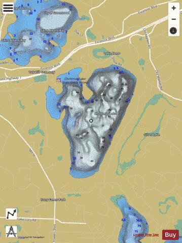
Christmas Fishing Map Stats | |
| Title | Christmas |
| Scale | 1:6000 |
| Counties | Carver, Hennepin |
| Nearby Cities | Greenwood, Excelsior, Chanhassen, Deephaven, Shorewood, Tonka Bay, Minnetonka Beach, Woodland, Minnetonka, Wayzata |
| Area * | 267.37 acres |
| Shoreline * | 3.80 miles |
| Min Longitude | -93.55 |
| Min Latitude | 44.89 |
| Max Longitude | -93.54 |
| Max Latitude | 44.90 |
| Edition Label 1 | |
| Edition Label 2 | |
| Edition Label 3 | |
| Id | US_MN_27013700 |
| Country | US |
| Projection | Mercator |
| * some Stats may include nearby/connecting waterbodies | |
|