Bush fishing map is available as part of iBoating : USA Marine & Fishing App(now supported on multiple platforms including Android, iPhone/iPad, MacBook, and Windows(tablet and phone)/PC based chartplotter.).
With our Lake Maps App, you get all the great marine chart app features like fishing spots, along with Bush lake depth map. The fishing maps app include HD lake depth contours, along with advanced features found in Fish Finder / Gps Chart Plotter systems, turning your device into a Depth Finder. The Bush Navigation App provides advanced features of a Marine Chartplotter including adjusting water level offset and custom depth shading. Fishing spots and depth contours layers are available in most Lake maps. Lake navigation features include advanced instrumentation to gather wind speed direction, water temperature, water depth, and accurate GPS with AIS receivers(using NMEA over TCP/UDP). Autopilot support can be enabled during ‘Goto WayPoint’ and ‘Route Assistance’.
Now i-Boating supports Fishing Points in Bush.
Have more questions about the Nautical Chart App? Ask us.
Fishing Info for Bush
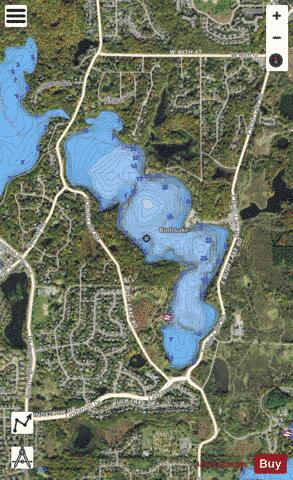
Bush Lake is located in the southwest corner of the Minneapolis suburb of Bloomington, Minnesota, near its border with Eden Prairie in Hennepin County. It has an area of 172.2 acres (69.7 ha) and a maximum depth of 28.0 feet (8.5 m). The lake contains many fish, but primarily Bluegill, Northern Pike, Pumpkinseed Sunfish, Yellow Bullhead, Yellow Perch. Bush Lake is near Hyland Lake Park Reserve.
More on Wikipedia...Popular fish species in this lake include Pumpkinseed.
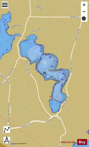
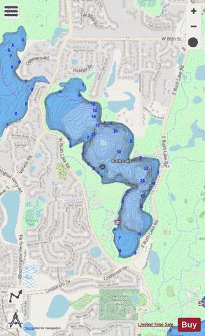
Bush Fishing Map Stats | |
| Title | Bush |
| Scale | 1:3000 |
| Counties | Hennepin |
| Nearby Cities | Barden, Edina, Savage, Bloomington, Eden Prairie, Hopkins, Richfield, Saint Louis Park, Burnsville, Prior Lake |
| Area * | 181.80 acres |
| Shoreline * | 3.59 miles |
| Min Longitude | -93.39 |
| Min Latitude | 44.83 |
| Max Longitude | -93.38 |
| Max Latitude | 44.84 |
| Edition Label 1 | |
| Edition Label 2 | |
| Edition Label 3 | |
| Id | US_MN_27004700 |
| Country | US |
| Projection | Mercator |
| * some Stats may include nearby/connecting waterbodies | |
|