Long Lake fishing map is available as part of iBoating : USA Marine & Fishing App(now supported on multiple platforms including Android, iPhone/iPad, MacBook, and Windows(tablet and phone)/PC based chartplotter.).
With our Lake Maps App, you get all the great marine chart app features like fishing spots, along with Long Lake depth map. The fishing maps app include HD lake depth contours, along with advanced features found in Fish Finder / Gps Chart Plotter systems, turning your device into a Depth Finder. The Long Lake Navigation App provides advanced features of a Marine Chartplotter including adjusting water level offset and custom depth shading. Fishing spots and depth contours layers are available in most Lake maps. Lake navigation features include advanced instrumentation to gather wind speed direction, water temperature, water depth, and accurate GPS with AIS receivers(using NMEA over TCP/UDP). Autopilot support can be enabled during ‘Goto WayPoint’ and ‘Route Assistance’.
Now i-Boating supports Fishing Points in Long Lake.
Have more questions about the Nautical Chart App? Ask us.
Fishing Info for Long Lake
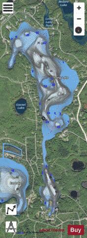
Long Lake (formerly Eagle Lake) is a 295-acre (119 ha) lake in northeastern Montmorency County, Michigan. The lake is primarily in Montmorency Township, although the southernmost portion is located in Hillman Township, as well as part of the Mackinaw State Forest. The nearest town is Hillman at about 6 miles (9.7 km) southeast of the lake.
More on Wikipedia...Popular fish species in this lake include Largemouth bass, Northern pike, Rainbow trout, Rock bass, Smallmouth bass, Walleye and Yellow perch.
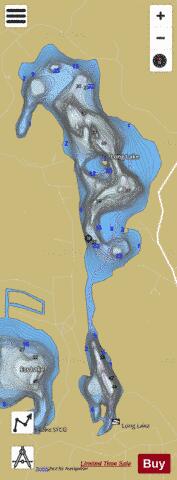
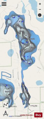
Long Lake Fishing Map Stats | |
| Title | Long Lake |
| Scale | 1:12000 |
| Includes Data from Fish Atlas | Yes |
| Counties | Montmorency |
| Nearby Cities | Hillman, Hawks, Atlanta, Millersburg, Canada Creek Ranch, Lachine, Posen, Rogers City, Onaway, Huron Beach |
| Area * | 279.48 acres |
| Shoreline * | 5.69 miles |
| Min Longitude | -83.98 |
| Min Latitude | 45.11 |
| Max Longitude | -83.97 |
| Max Latitude | 45.14 |
| Edition Label 1 | |
| Edition Label 2 | |
| Edition Label 3 | |
| Id | US_MI_60_166 |
| Country | US |
| Projection | Mercator |
| * some Stats may include nearby/connecting waterbodies | |
|