Little Long Lake fishing map is available as part of iBoating : USA Marine & Fishing App(now supported on multiple platforms including Android, iPhone/iPad, MacBook, and Windows(tablet and phone)/PC based chartplotter.).
With our Lake Maps App, you get all the great marine chart app features like fishing spots, along with Little Long Lake depth map. The fishing maps app include HD lake depth contours, along with advanced features found in Fish Finder / Gps Chart Plotter systems, turning your device into a Depth Finder. The Little Long Lake Navigation App provides advanced features of a Marine Chartplotter including adjusting water level offset and custom depth shading. Fishing spots and depth contours layers are available in most Lake maps. Lake navigation features include advanced instrumentation to gather wind speed direction, water temperature, water depth, and accurate GPS with AIS receivers(using NMEA over TCP/UDP). Autopilot support can be enabled during ‘Goto WayPoint’ and ‘Route Assistance’.
Now i-Boating supports Fishing Points in Little Long Lake.
Have more questions about the Nautical Chart App? Ask us.
Fishing Info for Little Long Lake
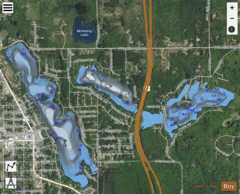
Little Long Lake is a small fresh water lake located in Harrison and Hayes Township in Clare County in the U.S. state of Michigan. The lake encompasses 43 acres (17 ha). Little Long Lake is bisected by U.S. Highway 127, and a small canal travels under the highway to connect the two segments. Budd Lake is to the west, is to the north, and is to the east. However, Little Long Lake does not connect to any other lake. Little Long Lake should not be confused with slightly north in Frost Township or any of the other similarly named lakes in Michigan. While the lake is mostly surrounded by private residences, there is one public access boat launch in the far northwest corner of the lake on Hammond Road. With depths of at least 50 feet (15 m), common fish in the lake include black crappie, brook and brown trout, bluegill, largemouth bass, northern pike, pumpkinseed, rock bass, and yellow perch.
More on Wikipedia...Popular fish species in this lake include Black crappie, Brook trout, Largemouth bass, Northern pike, Pumpkinseed, Rock bass and Yellow perch.
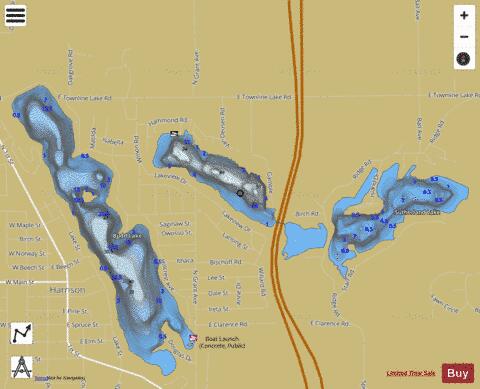
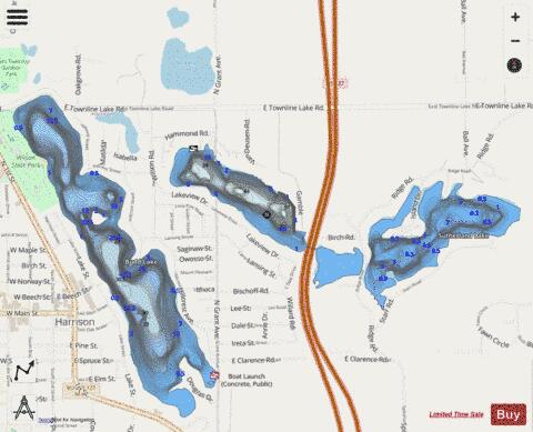
Little Long Lake Fishing Map Stats | |
| Title | Little Long Lake |
| Scale | 1:6000 |
| Includes Data from Fish Atlas | Yes |
| Counties | Clare |
| Nearby Cities | Harrison, Lake George, Clare, Farwell, Moddersville, Loomis, Houghton Lake, Gladwin, Prudenville, Rosebush |
| Area * | 68.22 acres |
| Shoreline * | 2.51 miles |
| Min Longitude | -84.79 |
| Min Latitude | 44.02 |
| Max Longitude | -84.78 |
| Max Latitude | 44.03 |
| Edition Label 1 | |
| Edition Label 2 | |
| Edition Label 3 | |
| Id | US_MI_18_215 |
| Country | US |
| Projection | Mercator |
| * some Stats may include nearby/connecting waterbodies | |
|