Beau Lake fishing map is available as part of iBoating : USA Marine & Fishing App(now supported on multiple platforms including Android, iPhone/iPad, MacBook, and Windows(tablet and phone)/PC based chartplotter.).
With our Lake Maps App, you get all the great marine chart app features like fishing spots, along with Beau Lake depth map. The fishing maps app include HD lake depth contours, along with advanced features found in Fish Finder / Gps Chart Plotter systems, turning your device into a Depth Finder. The Beau Lake Navigation App provides advanced features of a Marine Chartplotter including adjusting water level offset and custom depth shading. Fishing spots and depth contours layers are available in most Lake maps. Lake navigation features include advanced instrumentation to gather wind speed direction, water temperature, water depth, and accurate GPS with AIS receivers(using NMEA over TCP/UDP). Autopilot support can be enabled during ‘Goto WayPoint’ and ‘Route Assistance’.
Now i-Boating supports Fishing Points in Beau Lake.
Have more questions about the Nautical Chart App? Ask us.
Fishing Info for Beau Lake
The Beau Lake (in French: "Le Beau Lac") is a freshwater lake in the north–south axis through the Saint Francis River. The lake is the center of the boundary between: * Maine (United States): North Maine Woods, Aroostook County, , township T20 R11 & R12 Wels (northern part of the western shore of the lake) and T19 R11 Wels; * Quebec (Canada): administrative region of Bas-Saint-Laurent, regional county municipality (RCM) Témiscouata Regional County Municipality, in municipality of Rivière-Bleue, Quebec. This lake is located entirely in the forest zone. In the story, the main economic activity was forestry. Since the mid-twentieth century, the resort and tourist activities have developed. This lake is particularly renowned for fishing and recreational boating in particular because of its mountainous landscape. On the side of Maine, a forest road runs along the western shore of the lake. While the side of the Quebec, a few dozen homes are served by an access road to the northern half of the lake.
More on Wikipedia...
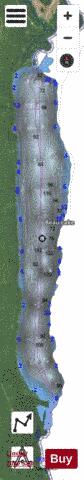
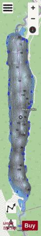
Beau Lake Fishing Map Stats | |
| Title | Beau Lake |
| Scale | 1:6000 |
| Counties | Aroostook |
| Nearby Cities | Dickey, Saint Francis, Allagash, Fort Kent, Wallagrass, Soldier Pond, Eagle Lake, Winterville, Saint Agatha, Portage |
| Area * | 1832.07 acres |
| Shoreline * | 13.97 miles |
| Min Longitude | -69.06 |
| Min Latitude | 47.30 |
| Max Longitude | -69.04 |
| Max Latitude | 47.38 |
| Edition Label 1 | |
| Edition Label 2 | |
| Edition Label 3 | |
| Id | US_ME_beau_lake |
| Country | US |
| Projection | Mercator |
| * some Stats may include nearby/connecting waterbodies | |
|