Lovewell Pond fishing map is available as part of iBoating : USA Marine & Fishing App(now supported on multiple platforms including Android, iPhone/iPad, MacBook, and Windows(tablet and phone)/PC based chartplotter.).
With our Lake Maps App, you get all the great marine chart app features like fishing spots, along with Lovewell Pond depth map. The fishing maps app include HD lake depth contours, along with advanced features found in Fish Finder / Gps Chart Plotter systems, turning your device into a Depth Finder. The Lovewell Pond Navigation App provides advanced features of a Marine Chartplotter including adjusting water level offset and custom depth shading. Fishing spots and depth contours layers are available in most Lake maps. Lake navigation features include advanced instrumentation to gather wind speed direction, water temperature, water depth, and accurate GPS with AIS receivers(using NMEA over TCP/UDP). Autopilot support can be enabled during ‘Goto WayPoint’ and ‘Route Assistance’.
Now i-Boating supports Fishing Points in Lovewell Pond.
Have more questions about the Nautical Chart App? Ask us.
Fishing Info for Lovewell Pond
Lovewell Pond is a sizable body of water located in southeastern Fryeburg, Maine. It has a moderately developed shoreline with approximately 75-80 buildings, not including approximately 35 others with access rights to the pond's shoreline. Lovewell Pond is the second largest pond in Oxford County. It is about 1,120 acres (450 ha), slightly smaller than Kezar Pond, which is about 1,299 acres (526 ha). Lovewell Pond does, however, fluctuate largely in size due to its annual flooding phenomenon. It is the drainage basin for many small streams including Fight Brook and Mill/Wards Brook, but mainly the Saco River, which acts as both an inlet and outlet for the pond. When the Saco River floods, the water, which normally flows out, reverses direction and flows into the pond, causing it to rise. Lovewell Pond has an actual drainage area of about 3,101 acres (1,255 ha). This flooding is an unusual characteristic for a pond. Lovewell Pond has a maximum depth of 45 feet (14 m) during dry season, but can increase by as much as 10 feet (3.0 m), depending on how high the water rises during rainy periods. The water is normally lowest in the summer (August) and highest in the spring (April).
More on Wikipedia...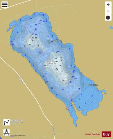
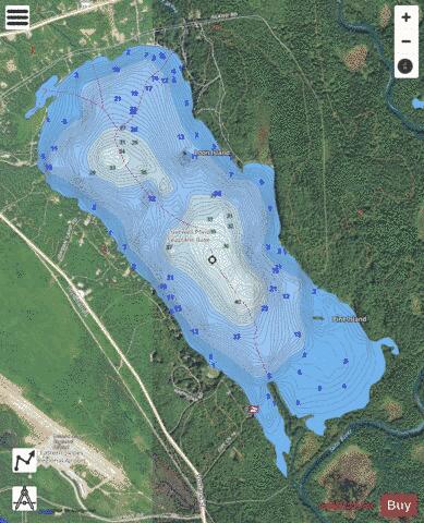
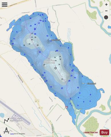
Lovewell Pond Fishing Map Stats | |
| Title | Lovewell Pond |
| Scale | 1:6000 |
| Counties | Oxford |
| Nearby Cities | Fryeburg, Brownfield, Denmark, Lovell, Stow, Chatham, Sweden, Hiram, Conway, North Conway |
| Area * | 1116.65 acres |
| Shoreline * | 8.70 miles |
| Min Longitude | -70.95 |
| Min Latitude | 43.99 |
| Max Longitude | -70.91 |
| Max Latitude | 44.02 |
| Edition Label 1 | |
| Edition Label 2 | |
| Edition Label 3 | |
| Id | US_ME_00581451 |
| Country | US |
| Projection | Mercator |
| * some Stats may include nearby/connecting waterbodies | |
|