Trickey Pond fishing map is available as part of iBoating : USA Marine & Fishing App(now supported on multiple platforms including Android, iPhone/iPad, MacBook, and Windows(tablet and phone)/PC based chartplotter.).
With our Lake Maps App, you get all the great marine chart app features like fishing spots, along with Trickey Pond depth map. The fishing maps app include HD lake depth contours, along with advanced features found in Fish Finder / Gps Chart Plotter systems, turning your device into a Depth Finder. The Trickey Pond Navigation App provides advanced features of a Marine Chartplotter including adjusting water level offset and custom depth shading. Fishing spots and depth contours layers are available in most Lake maps. Lake navigation features include advanced instrumentation to gather wind speed direction, water temperature, water depth, and accurate GPS with AIS receivers(using NMEA over TCP/UDP). Autopilot support can be enabled during ‘Goto WayPoint’ and ‘Route Assistance’.
Now i-Boating supports Fishing Points in Trickey Pond.
Have more questions about the Nautical Chart App? Ask us.
Fishing Info for Trickey Pond
Trickey Pond is a water body in the U.S. state of Maine. Its maximum depth is 55 feet (17 m). The lack of serious pollution in the area contributes to the pond's remarkably good water clarity. At most points in the pond, the entire depth can be seen.
More on Wikipedia...Popular fish species in this lake include Brook trout, Chain pickerel, Golden shiner, Lake trout, Largemouth bass, Rainbow smelt, Sculpin, Smallmouth bass, White sucker and Yellow perch.
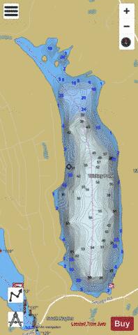
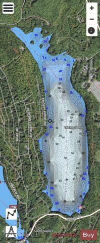
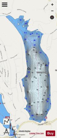
Trickey Pond Fishing Map Stats | |
| Title | Trickey Pond |
| Scale | 1:6000 |
| Counties | Cumberland |
| Nearby Cities | Naples, Casco, Frye Island, Raymond, Bridgton, Steep Falls, Harrison, Denmark, North Windham, Hiram |
| Area * | 315.43 acres |
| Shoreline * | 4.77 miles |
| Min Longitude | -70.62 |
| Min Latitude | 43.93 |
| Max Longitude | -70.60 |
| Max Latitude | 43.95 |
| Edition Label 1 | |
| Edition Label 2 | |
| Edition Label 3 | |
| Id | US_ME_00577311 |
| Country | US |
| Projection | Mercator |
| * some Stats may include nearby/connecting waterbodies | |
|