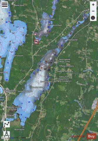
Messalonskee Lake fishing map is available as part of iBoating : USA Marine & Fishing App(now supported on multiple platforms including Android, iPhone/iPad, MacBook, and Windows(tablet and phone)/PC based chartplotter.).
With our Lake Maps App, you get all the great marine chart app features like fishing spots, along with Messalonskee Lake depth map. The fishing maps app include HD lake depth contours, along with advanced features found in Fish Finder / Gps Chart Plotter systems, turning your device into a Depth Finder. The Messalonskee Lake Navigation App provides advanced features of a Marine Chartplotter including adjusting water level offset and custom depth shading. Fishing spots and depth contours layers are available in most Lake maps. Lake navigation features include advanced instrumentation to gather wind speed direction, water temperature, water depth, and accurate GPS with AIS receivers(using NMEA over TCP/UDP). Autopilot support can be enabled during ‘Goto WayPoint’ and ‘Route Assistance’.
Now i-Boating supports Fishing Points in Messalonskee Lake.
Have more questions about the Nautical Chart App? Ask us.
Fishing Info for Messalonskee Lake
Messalonskee Lake is a body of water in the Belgrade Lakes region of Maine. It is bordered by the towns of Oakland, Sidney, and Belgrade. The lake is a 9-mile-long, narrow, natural creation, resulting from continental collision and glacial scouring. A dam originally built in the town of Oakland in 1905 increased the lake's size. In the first part of the 20th century, Messalonskee Stream provided waterpower for Oakland's Cascade Woolen Mill, as well as for a number of factories responsible for Oakland's long-defunct title as "axehead capital of the world." Messalonskee Lake is home to a great variety of wildlife, including great blue herons, bass, yellow perch, white perch, sunfish, painted and snapping turtles, loons, and occasionally Bald Eagles can be seen soaring above the lake. The surrounding community has recently formed the Messalonskee Lake Association in the interest of its protection and preservation. Like some Maine lakes, Messalonskee Lake has seen infestations of Milfoil. The lake is also more commonly called "Snow Pond", a reference to Philip Snow who settled in the area in 1774. Many summer camps and related tourist accommodations are located on Messalonskee Lake, among them the New England Music Camp, which was founded in 1937.
More on Wikipedia...Popular fish species in this lake include Yellow perch.
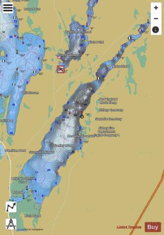
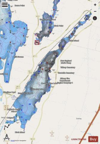
Messalonskee Lake Fishing Map Stats | |
| Title | Messalonskee Lake |
| Scale | 1:12000 |
| Counties | Kennebec |
| Nearby Cities | Oakland, Belgrade, Sidney, Waterville, Vassalboro, Winslow, Manchester, Rome, Augusta, Smithfield |
| Area * | 3694.13 acres |
| Shoreline * | 30.05 miles |
| Min Longitude | -69.83 |
| Min Latitude | 44.44 |
| Max Longitude | -69.72 |
| Max Latitude | 44.54 |
| Edition Label 1 | |
| Edition Label 2 | |
| Edition Label 3 | |
| Id | US_ME_00571183 |
| Country | US |
| Projection | Mercator |
| * some Stats may include nearby/connecting waterbodies | |
|