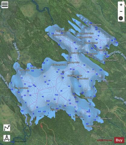
Baskahegan Lake fishing map is available as part of iBoating : USA Marine & Fishing App(now supported on multiple platforms including Android, iPhone/iPad, MacBook, and Windows(tablet and phone)/PC based chartplotter.).
With our Lake Maps App, you get all the great marine chart app features like fishing spots, along with Baskahegan Lake depth map. The fishing maps app include HD lake depth contours, along with advanced features found in Fish Finder / Gps Chart Plotter systems, turning your device into a Depth Finder. The Baskahegan Lake Navigation App provides advanced features of a Marine Chartplotter including adjusting water level offset and custom depth shading. Fishing spots and depth contours layers are available in most Lake maps. Lake navigation features include advanced instrumentation to gather wind speed direction, water temperature, water depth, and accurate GPS with AIS receivers(using NMEA over TCP/UDP). Autopilot support can be enabled during ‘Goto WayPoint’ and ‘Route Assistance’.
Now i-Boating supports Fishing Points in Baskahegan Lake.
Have more questions about the Nautical Chart App? Ask us.
Fishing Info for Baskahegan Lake
Baskahegan Lake is a body of water in Washington County, Maine, United States. The lake, which covers 6,815 acres (2,758 ha), is the third largest lake in Washington County and one of the largest statewide. It is located in the town of Topsfield, Maine, the former township of Brookton (North Washington, Maine). The picturesque lake is known for its warm water fishery and very high water quality. In 2007, Evergreen Wind Power LLC sought to build on Stetson Mountain, which would be visible from the boat launch on Baskahegan Lake near Brookton, nine miles away. As of 2009, the installation on Stetson Mountain was the largest wind power operation in New England.
More on Wikipedia...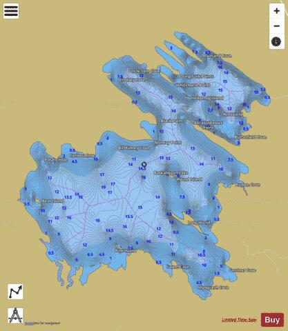
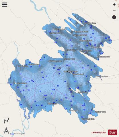
Baskahegan Lake Fishing Map Stats | |
| Title | Baskahegan Lake |
| Scale | 1:12000 |
| Counties | Washington |
| Nearby Cities | Brookton, Topsfield, Danforth, Waite, Weston, Bancroft, Wytopitlock, Orient, Springfield, Haynesville |
| Area * | 6818.59 acres |
| Shoreline * | 41.36 miles |
| Min Longitude | -67.88 |
| Min Latitude | 45.47 |
| Max Longitude | -67.78 |
| Max Latitude | 45.54 |
| Edition Label 1 | |
| Edition Label 2 | |
| Edition Label 3 | |
| Id | US_ME_00561695 |
| Country | US |
| Projection | Mercator |
| * some Stats may include nearby/connecting waterbodies | |
|