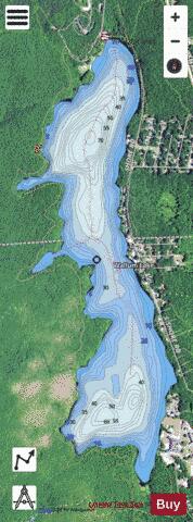
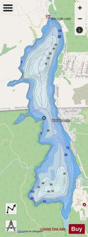
Wallum Lake fishing map is available as part of iBoating : USA Marine & Fishing App(now supported on multiple platforms including Android, iPhone/iPad, MacBook, and Windows(tablet and phone)/PC based chartplotter.).
With our Lake Maps App, you get all the great marine chart app features like fishing spots, along with Wallum Lake depth map. The fishing maps app include HD lake depth contours, along with advanced features found in Fish Finder / Gps Chart Plotter systems, turning your device into a Depth Finder. The Wallum Lake Navigation App provides advanced features of a Marine Chartplotter including adjusting water level offset and custom depth shading. Fishing spots and depth contours layers are available in most Lake maps. Lake navigation features include advanced instrumentation to gather wind speed direction, water temperature, water depth, and accurate GPS with AIS receivers(using NMEA over TCP/UDP). Autopilot support can be enabled during ‘Goto WayPoint’ and ‘Route Assistance’.
Now i-Boating supports Fishing Points in Wallum Lake.
Have more questions about the Nautical Chart App? Ask us.
Fishing Info for Wallum Lake
Wallum Lake is a 322-acre (1.30 km2) lake that lies in Burrillville, Providence County, Rhode Island and Douglas, Worcester County, Massachusetts. It is adjacent to Douglas State Forest and . There are two paved boat ramps: one at the north end off Wallum Lake Road, Douglas, Massachusetts, the second at the southern extreme in Burrillville, Rhode Island. A study reported ten species of fish, based upon a 1994 summer sampling. Largemouth bass, yellow perch and bluegills are common. Additional species present included pumpkinseed, chain pickerel, landlocked alewife, brood salmon and eels. Licenses from either state are valid, but Rhode Island regulations apply. Wallum Lake has been stocked with rainbow trout and brown trout. Rainbow trout are stocked on a put-and-take basis, and the state of Rhode Island has stocked numerous landlocked salmon and occasionally broodstock salmon.
More on Wikipedia...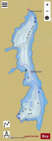
Wallum Lake Fishing Map Stats | |
| Title | Wallum Lake |
| Scale | 1:6000 |
| Counties | Worcester, Providence |
| Nearby Cities | Douglas, Pascoag, East Douglas, Harrisville, Thompson, Webster, Chepachet, North Grosvenor Dale, Sutton, Whitinsville |
| Area * | 312.43 acres |
| Shoreline * | 5.53 miles |
| Min Longitude | -71.78 |
| Min Latitude | 41.99 |
| Max Longitude | -71.76 |
| Max Latitude | 42.02 |
| Edition Label 1 | |
| Edition Label 2 | |
| Edition Label 3 | |
| Id | US_MA_malac_wallum_lake |
| Country | US |
| Projection | Mercator |
| * some Stats may include nearby/connecting waterbodies | |
|