Eightmile Lake fishing map is available as part of iBoating : USA Marine & Fishing App(now supported on multiple platforms including Android, iPhone/iPad, MacBook, and Windows(tablet and phone)/PC based chartplotter.).
With our Lake Maps App, you get all the great marine chart app features like fishing spots, along with Eightmile Lake depth map. The fishing maps app include HD lake depth contours, along with advanced features found in Fish Finder / Gps Chart Plotter systems, turning your device into a Depth Finder. The Eightmile Lake Navigation App provides advanced features of a Marine Chartplotter including adjusting water level offset and custom depth shading. Fishing spots and depth contours layers are available in most Lake maps. Lake navigation features include advanced instrumentation to gather wind speed direction, water temperature, water depth, and accurate GPS with AIS receivers(using NMEA over TCP/UDP). Autopilot support can be enabled during ‘Goto WayPoint’ and ‘Route Assistance’.
Now i-Boating supports Fishing Points in Eightmile Lake.
Have more questions about the Nautical Chart App? Ask us.
Fishing Info for Eightmile Lake
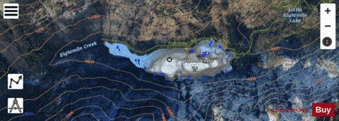
Eightmile Lake is a reservoir lake located on the eastern slope of Eightmile Mountain, in Chelan County in Washington. It is a reservoir lake formed along the beginning route of Eightmile Creek as it exits Jack Ridge. The lake is located approximately 10 miles from the city of Leavenworth, Washington. It is accessed by a 3.5-mile trail (USFS Trail No. 1552) that starts at USFS Road 7601 as it crosses over Eighmile Creek and makes a turn towards the Stuart and Culchuck Lake Trailhead where the road ends. Self-issued Alpine Lake Wilderness permit required for transit within the Eightmile Lake area.
More on Wikipedia...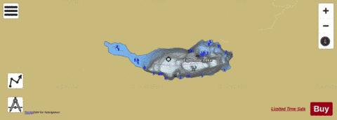
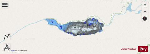
Eightmile Lake Fishing Map Stats | |
| Title | Eightmile Lake |
| Scale | 1:6000 |
| Counties | Chelan |
| Nearby Cities | Leavenworth, Winton, Peshastin, Merritt, Plain, Roslyn, Ronald, Telma, Liberty, Cle Elum |
| Area * | 63.68 acres |
| Shoreline * | 1.89 miles |
| Min Longitude | -120.87 |
| Min Latitude | 47.52 |
| Max Longitude | -120.86 |
| Max Latitude | 47.52 |
| Edition Label 1 | |
| Edition Label 2 | |
| Edition Label 3 | |
| Id | US_LM_us_wa_ch_24n16e_eightmile |
| Country | US |
| Projection | Mercator |
| * some Stats may include nearby/connecting waterbodies | |
|