Conneaut Lake fishing map is available as part of iBoating : USA Marine & Fishing App(now supported on multiple platforms including Android, iPhone/iPad, MacBook, and Windows(tablet and phone)/PC based chartplotter.).
With our Lake Maps App, you get all the great marine chart app features like fishing spots, along with Conneaut Lake depth map. The fishing maps app include HD lake depth contours, along with advanced features found in Fish Finder / Gps Chart Plotter systems, turning your device into a Depth Finder. The Conneaut Lake Navigation App provides advanced features of a Marine Chartplotter including adjusting water level offset and custom depth shading. Fishing spots and depth contours layers are available in most Lake maps. Lake navigation features include advanced instrumentation to gather wind speed direction, water temperature, water depth, and accurate GPS with AIS receivers(using NMEA over TCP/UDP). Autopilot support can be enabled during ‘Goto WayPoint’ and ‘Route Assistance’.
Now i-Boating supports Fishing Points in Conneaut Lake.
Have more questions about the Nautical Chart App? Ask us.
Fishing Info for Conneaut Lake
Conneaut Lake /ˈkɒniˌɔːt/ is the largest natural lake in Pennsylvania by surface area. It is located in western Crawford County near a town with the same name. Its has a surface area of approximately 925 acres. The site of the lake is actually in adjacent Sadsbury Township and nearby Summit Township. During the summer season, it is heavily populated with people vacationing to the lake area, some from the area spending time in their houses on the lake, and many others from the surrounding area that like to spend the summer away from home, many of these people being residents of the Pittsburgh area. Other than the lake itself, the largest draw to the area has long been a popular resort known as Conneaut Lake Park, long known for its amusement park.
More on Wikipedia...Popular fish species in this lake include Muskellunge/Walleye/Northern Pike.
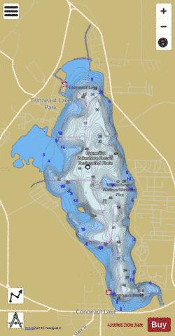
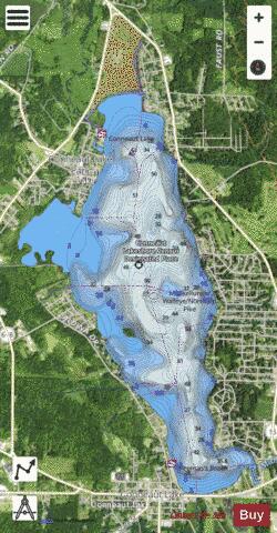
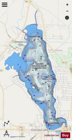
Conneaut Lake Fishing Map Stats | |
| Title | Conneaut Lake |
| Scale | 1:3000 |
| Counties | Crawford |
| Nearby Cities | Conneaut Lake, Harmonsburg, Geneva, Hartstown, Linesville, Atlantic, Adamsville, Fredericksburg, Conneautville, Kerrtown |
| Area * | 1099.18 acres |
| Shoreline * | 11.74 miles |
| Min Longitude | -80.32 |
| Min Latitude | 41.60 |
| Max Longitude | -80.29 |
| Max Latitude | 41.65 |
| Edition Label 1 | |
| Edition Label 2 | |
| Edition Label 3 | |
| Id | US_LM_us_pa_cw_sb_conneaut |
| Country | US |
| Projection | Mercator |
| * some Stats may include nearby/connecting waterbodies | |
|