Dewart Lake fishing map is available as part of iBoating : USA Marine & Fishing App(now supported on multiple platforms including Android, iPhone/iPad, MacBook, and Windows(tablet and phone)/PC based chartplotter.).
With our Lake Maps App, you get all the great marine chart app features like fishing spots, along with Dewart Lake depth map. The fishing maps app include HD lake depth contours, along with advanced features found in Fish Finder / Gps Chart Plotter systems, turning your device into a Depth Finder. The Dewart Lake Navigation App provides advanced features of a Marine Chartplotter including adjusting water level offset and custom depth shading. Fishing spots and depth contours layers are available in most Lake maps. Lake navigation features include advanced instrumentation to gather wind speed direction, water temperature, water depth, and accurate GPS with AIS receivers(using NMEA over TCP/UDP). Autopilot support can be enabled during ‘Goto WayPoint’ and ‘Route Assistance’.
Now i-Boating supports Fishing Points in Dewart Lake.
Have more questions about the Nautical Chart App? Ask us.
Fishing Info for Dewart Lake
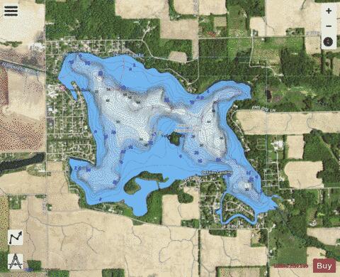
Dewart Lake, (formerly Lake Wawasee before Turkey Lake became Lake Wawasee), is a natural lake southwest of Syracuse in Kosciusko County, Indiana, United States. It was formed during the most recent glacial retreat of the Pleistocene era. Dewart Lake is a 551-acre (223 ha) natural lake, located three miles (4.8 km) south of Syracuse and three miles (4.8 km) east of Indiana State Road 15. 41 degrees 22' 03.31" North Latitude x 85 degrees 46' 18.22" West Longitude, 867.70 feet (264.47 m) above Sea Level. 82 feet (25 m) is the maximum depth with an average depth of 16.3 feet (5.0 m). It lies within the Elkhart River watershed and drains 5,152 acres (2,085 ha). Two small inlets enter on the east side and the outlet, Hammond Ditch, leaves the west side and flows to Waubee Lake. Large areas on the north and south sides of the lake are less than 5 feet (1.5 m) deep. Hydraulic retention time is 601 days. Farming is the main watershed use, although woodlots and wetlands are present. Nearly all of the shoreline is residentially developed. Areas of natural shoreline and wetlands are present along the south shore and in the northeast corner adjacent to a private camp. A state-owned boat ramp is available in the northwest corner on CR 300E. Dewart Lake is moderately fertile. Its trophic index is 36. Enough oxygen is present for fish 20 deep but levels drop too low below 20 feet (less than 4 ppm.). Water clarity varies from 6 through 13 1/2 feet. The bottom is mostly sand and muck, but boulders and gravel are also present. Eurasian Water Millfol is the dominant submerged aquatic plant. (The lake was treated for this non-indeginoous plant in 2006.) Cattails, spatterdock and water lilies are the major emergent plants. In recent years, an extensive cattail stand along the south shore has been replaced with lilies. Some past management at Dewart Lake has been directed at maintaining the native fishery and creating walleye fishing opportunities.
More on Wikipedia...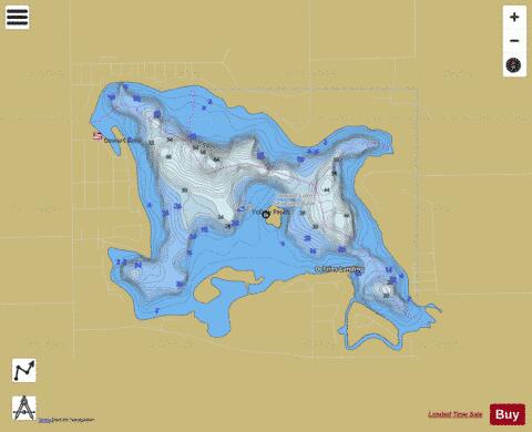
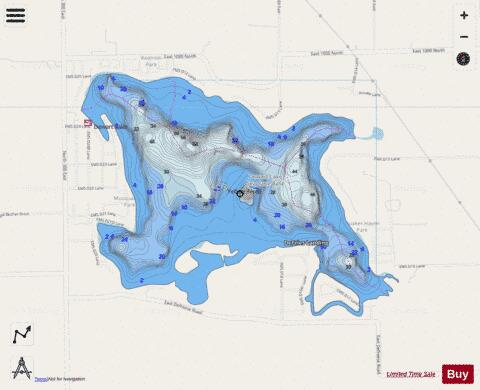
Dewart Lake Fishing Map Stats | |
| Title | Dewart Lake |
| Scale | 1:3000 |
| Counties | Kosciusko |
| Nearby Cities | Syracuse, Milford, North Webster, Leesburg, New Paris, Winona Lake, Warsaw, Cromwell, Millersburg, Pierceton |
| Area * | 547.87 acres |
| Shoreline * | 8.31 miles |
| Min Longitude | -85.79 |
| Min Latitude | 41.36 |
| Max Longitude | -85.76 |
| Max Latitude | 41.38 |
| Edition Label 1 | |
| Edition Label 2 | |
| Edition Label 3 | |
| Id | US_IN_00433518 |
| Country | US |
| Projection | Mercator |
| * some Stats may include nearby/connecting waterbodies | |
|