Lake Conine fishing map is available as part of iBoating : USA Marine & Fishing App(now supported on multiple platforms including Android, iPhone/iPad, MacBook, and Windows(tablet and phone)/PC based chartplotter.).
With our Lake Maps App, you get all the great marine chart app features like fishing spots, along with Lake Conine depth map. The fishing maps app include HD lake depth contours, along with advanced features found in Fish Finder / Gps Chart Plotter systems, turning your device into a Depth Finder. The Lake Conine Navigation App provides advanced features of a Marine Chartplotter including adjusting water level offset and custom depth shading. Fishing spots and depth contours layers are available in most Lake maps. Lake navigation features include advanced instrumentation to gather wind speed direction, water temperature, water depth, and accurate GPS with AIS receivers(using NMEA over TCP/UDP). Autopilot support can be enabled during ‘Goto WayPoint’ and ‘Route Assistance’.
Now i-Boating supports Fishing Points in Lake Conine.
Have more questions about the Nautical Chart App? Ask us.
Fishing Info for Lake Conine
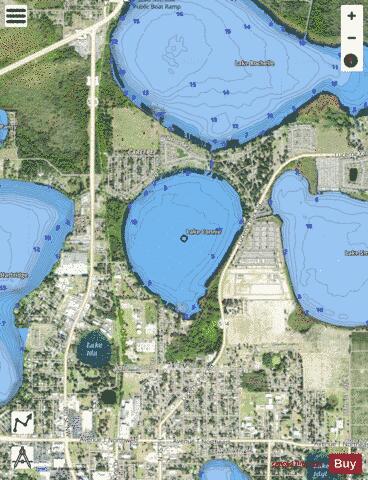
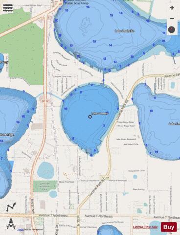
Lake Conine is a natural freshwater lake on the north side of Winter Haven, Florida. The lake is not within the city limits, but is almost entirely surrounded by the city of Winter Haven. Lake Conine is almost as often called Lake Connie as it is called Lake Conine. In fact, the Fishing Works website site has two listings calling this lake the former name and one calling it the latter. Lake Conine is bounded on the north and southwest by residential areas. On the west and southeast are woods. On the east the lake is bordered by SR 544 (Lucerne Park Road). Lake Conine has a 237-acre (960,000 m2) surface area and it is shaped somewhat like a teardrop. For many years Lake Conine received wastewater effluent. A study commissioned by Polk County in 1994 found the high level of effluent resulted in nutrient recycling from lake bottom sediments. The county paid the company that performed the lake research to apply liquid aluminum sulfate to the lake's surface to inactivate the nutrient recycling process, thus repairing the damage the wastewater effluent had caused. The whole project was completed in 1996. Lake Conine has no public swimming areas or public boat ramps. However, boaters may reach the lake from public ramps in other area lakes. This lake is connected into the Chain of Lakes. canal system, which links numerous area lakes. Lake Conine may be reached by canals from Lake Smart, Lake Rochelle and Lake Hartridge. Fishing is allowed and can be done by boat or shore. There is a large public right of way along SR 544. The Hook and Bullet website says the lake contains black drum, bigmouth buffalo and atlantic salmon.
More on Wikipedia...Popular fish species in this lake include Atlantic salmon.
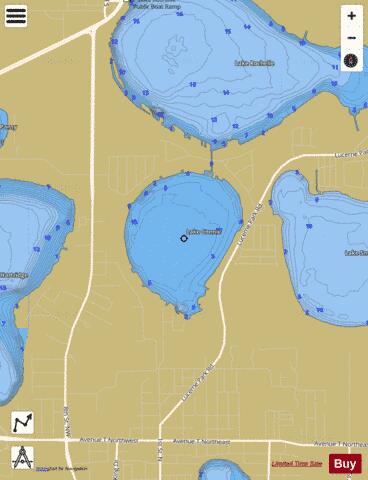
Lake Conine Fishing Map Stats | |
| Title | Lake Conine |
| Scale | 1:6000 |
| 1 ft Depth Contours for Anglers | Yes |
| Counties | Polk |
| Nearby Cities | Lake Alfred, Winter Haven, Inwood, Auburndale, Eagle Lake, Lake Hamilton, Wahneta, Dundee, Haines City, Waverly |
| Area * | 211.29 acres |
| Shoreline * | 2.76 miles |
| Min Longitude | -81.73 |
| Min Latitude | 28.05 |
| Max Longitude | -81.72 |
| Max Latitude | 28.07 |
| Edition Label 1 | |
| Edition Label 2 | |
| Edition Label 3 | |
| Id | US_FL_lake_conine_polk |
| Country | US |
| Projection | Mercator |
| * some Stats may include nearby/connecting waterbodies | |
|