Isabella Lake fishing map is available as part of iBoating : USA Marine & Fishing App(now supported on multiple platforms including Android, iPhone/iPad, MacBook, and Windows(tablet and phone)/PC based chartplotter.).
With our Lake Maps App, you get all the great marine chart app features like fishing spots, along with Isabella Lake depth map. The fishing maps app include HD lake depth contours, along with advanced features found in Fish Finder / Gps Chart Plotter systems, turning your device into a Depth Finder. The Isabella Lake Navigation App provides advanced features of a Marine Chartplotter including adjusting water level offset and custom depth shading. Fishing spots and depth contours layers are available in most Lake maps. Lake navigation features include advanced instrumentation to gather wind speed direction, water temperature, water depth, and accurate GPS with AIS receivers(using NMEA over TCP/UDP). Autopilot support can be enabled during ‘Goto WayPoint’ and ‘Route Assistance’.
Now i-Boating supports Fishing Points in Isabella Lake.
Have more questions about the Nautical Chart App? Ask us.
Fishing Info for Isabella Lake
Lake Isabella also called Isabella Lake, is a reservoir in Kern County, California, United States created by the earthen Isabella Dam. It was formed in 1953 when the U.S. Army Corps of Engineers dammed the Kern River at the junction of its two forks. At 11,000 acres (4,500 ha), it is one of the larger reservoirs in California. The area is in the southern end of the Sierra Nevada range and the lake itself is located in low mountains at an elevation of approximately 2,500 ft (760 m) where summer temperatures reach over 100 °F (38 °C) but low enough to avoid winter snows on the surrounding ridges. Lake Isabella is located about 40 miles (64 km) northeast of Bakersfield, and is the main water supply for that city. Lake Isabella can be reached by car from Bakersfield via state Highway 178 and from Delano via Highway 155. The former towns of Isabella and Kernville were flooded by the newly created reservoir.
More on Wikipedia...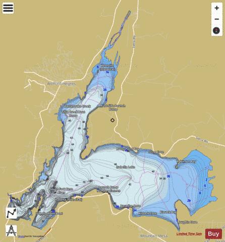
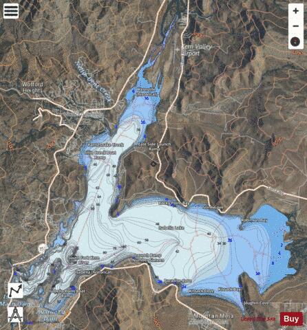
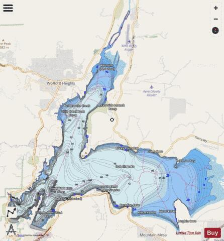
Isabella Lake Fishing Map Stats | |
| Title | Isabella Lake |
| Scale | 1:12000 |
| Counties | Kern |
| Nearby Cities | Wofford Heights, Mountain Mesa, Kernville, South Lake, Squirrel Mountain Valley, Lake Isabella, Bodfish, Weldon, Miracle Hot Springs, Onyx |
| Area * | 7690.26 acres |
| Shoreline * | 45.27 miles |
| Min Longitude | -118.49 |
| Min Latitude | 35.64 |
| Max Longitude | -118.37 |
| Max Latitude | 35.74 |
| Edition Label 1 | |
| Edition Label 2 | |
| Edition Label 3 | |
| Id | US_DL_CA_00271737 |
| Country | US |
| Projection | Mercator |
| * some Stats may include nearby/connecting waterbodies | |
|